IMAGES TAKEN NEAR TO
Wimborne Road, BOURNEMOUTH, BH10 7BY

Introduction

This page details the photographs taken nearby to Wimborne Road, BH10 7BY by members of the Geograph project.

The Geograph project started in 2005 with the aim of publishing, organising and preserving representative images for every square kilometre of Great Britain, Ireland and the Isle of Man.

There are currently over 7.5m images from over14,400 individuals and you can help contribute to the project by visiting https://www.geograph.org.uk

Image Map


Images are licensed for reuse under creativecommons.org/licenses/by-sa/2.0
Notes
  • Clicking on the map will re-center to the selected point.
  • The higher the marker number, the further away the image location is from the centre of the postcode.

Image Listing (102 Images Found)

Images are licensed for reuse under creativecommons.org/licenses/by-sa/2.0
  • ...
Image
Details
Distance
1
House on the Wimborne Road
A solid double fronted Edwardian villa that backs on to the A3060 Whitelegg Way and beyond that the Stour Valley nature Reserve
Image: © Nigel Mykura Taken: 15 Nov 2011
0.02 miles
2
Bournemouth : Wimborne Road
Wimborne Road is about five miles long - here it is at a junction with Headswell Avenue.
Image: © Lewis Clarke Taken: 11 Feb 2010
0.02 miles
3
Bournemouth : Wimborne Road
Wimborne Road with a bus stop - the 4B Yellow Bus may come by soon.
Image: © Lewis Clarke Taken: 11 Feb 2010
0.03 miles
4
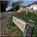
Northbourne: Headswell Avenue
Headswell Avenue is a longish road in the relatively well-to-do suburb of Northbourne, taking a course on the flat top of Red Hill before swinging in a big curve, as seen here, down the hill to meet Wimborne Road at an acute angle. The sharp left turn coming down the hill here onto Wimborne Road really is tight. The sign is from around 2000, and it morphed into another design, in blue rather than green and far more widely seen, including BOURNEMOUTH BOROUGH COUNCIL in smaller letters at the top, and the borough coat of arms on the left. This is photo no.185 of a series of 453 in my coronavirus lockdown walking project: See https://www.geograph.org.uk/article/My-2020-Coronavirus-Lockdown-walking-project for the complete set of photos.
Image: © Chris Downer Taken: 10 Apr 2020
0.04 miles
5
Redhill: western end of bridleway O16
Looking out of this rural feeling, wooded bridleway as it meets Wimborne Road. See Image for the view towards us from the pavement ahead, and Image for the view behind us and further links to see where it leads.
Image: © Chris Downer Taken: 6 Jul 2016
0.06 miles
6
Redhill: bridleway O16 leaves Wimborne Road
Looking along the pavement of Wimborne Road (the road itself is just to our right) as a short public bridleway diverges from it. The bridleway is a short one, at only 60m in length. It cuts the corner off compared with continuing along the pavement and turning left around the bend ahead. See Image for the view towards us from along the bridleway - and links to further photos to explore where it leads.
Image: © Chris Downer Taken: 6 Jul 2016
0.06 miles
7
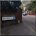
Redhill: Georgian Way
A fairly steep road off Wimborne Road, with a few rather nice houses in leafy grounds on the steep hillside to the right. It also forms a public right of way which continues as a footpath up to Headswell Crescent: See Image The road sign is a standard one from around 2000-2006, perhaps a little earlier, featuring the borough coat of arms. This is photo no.158 of a series of 453 in my coronavirus lockdown walking project: See https://www.geograph.org.uk/article/My-2020-Coronavirus-Lockdown-walking-project for the complete set of photos.
Image: © Chris Downer Taken: 13 Apr 2020
0.06 miles
8
Redhill: Georgian Way
A short cul-de-sac containing a few desirable houses, viewed from Wimborne Road. Georgian Way also forms public footpath O09, which continues beyond the dead end as a grassy path to Headswell Crescent. See Image for a view of the dead end and Image for the view up the grassy path.
Image: © Chris Downer Taken: 22 Jun 2016
0.06 miles
9
Redhill: muddy patch on bridleway O16
This looks like a very idyllic, rural route for a walk or a ride, but don't overestimate it - it is a very short public bridleway at only 60m long. It cuts the corner off between Wimborne Road behind us, and a paved bridleway ahead. See Image for the next view along the route ahead, with further links to photos along both routes, and Image for the view behind us.
Image: © Chris Downer Taken: 6 Jul 2016
0.07 miles
10
Redhill: approaching the subway on bridleway O14
This public bridleway links the two original parts of Wimborne Road which are now separated by the Whitelegg Way, which passes above the subway. See Image for the view towards us from the opening of the subway, and Image for the view behind us from roughly this spot.
Image: © Chris Downer Taken: 6 Jul 2016
0.07 miles
  • ...