IMAGES TAKEN NEAR TO
Romney Road, BOURNEMOUTH, BH10 6JR
Introduction
This page details the photographs taken nearby to Romney Road, BH10 6JR by members of the Geograph project.
The Geograph project started in 2005 with the aim of publishing, organising and preserving representative images for every square kilometre of Great Britain, Ireland and the Isle of Man.

There are currently over 7.5m images from over14,400 individuals and you can help contribute to the project by visiting https://www.geograph.org.uk
Image Map
Images are licensed for reuse under creativecommons.org/licenses/by-sa/2.0
Notes
- Clicking on the map will re-center to the selected point.
- The higher the marker number, the further away the image location is from the centre of the postcode.
Image Listing (72 Images Found)
Images are licensed for reuse under creativecommons.org/licenses/by-sa/2.0
Image
Details
Distance
1
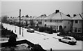
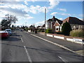
SZ082955: Looking North-North East on Romney Road
This photo was taken in December 2005 and looks out onto Romney Road from the Aberdare Road end. On the other end is Saxonhurst Road. The houses are predominantly detached with a smattering of semi-detached. Most of them were built in the 1930s. Prior to the housing development the area used to be the grounds of the Ensbury Race Course.
Image: © Kris
Taken: 29 Dec 2005
0.01 miles
2
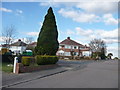
Bournemouth : Headswell Avenue
A tree on the junction of Headswell Avenue and Deanscroft Road.
Image: © Lewis Clarke
Taken: 11 Feb 2010
0.07 miles
3
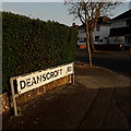
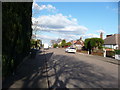
Northbourne: Deanscroft Road
Peering around the corner from Saxonhurst Road into this short, one-segment road with desirable detached houses typical of this part of Northbourne. Like many roads, this junction has a broadened triangular shape at each corner.
The sign is the standard Bournemouth nameplate from the 1980s, affixed with tubular steel which protrudes at each side.
This is photo no.105 of a series of 453 in my coronavirus lockdown walking project:
See https://www.geograph.org.uk/article/My-2020-Coronavirus-Lockdown-walking-project for the complete set of photos.
Image: © Chris Downer
Taken: 11 Apr 2020
0.07 miles
4
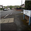
Northbourne: Aberdare Road
Alphabetically the first of the 451 roads within 2km of my home, Aberdare Road is in the relatively well-to-do Northbourne area and consists of bungalows.
We look across its one midway junction, with Romney Road to the left and Romney Close to the right.
The sign is of a design that became prevalent in Bournemouth around 1990 and was in use for most of that decade. Many are starting to look a bit shabby now but this one is still in pretty good nick.
This is photo no.1 of a series of 451 in my coronavirus lockdown walking project:
See https://www.geograph.org.uk/article/My-2020-Coronavirus-Lockdown-walking-project for the complete set of photos.
Image: © Chris Downer
Taken: 18 Apr 2020
0.07 miles
7
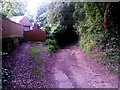
Redhill: rear garages accessed from Sandy Way
Sandy Way is a lane some 630m in length which forms public bridleway O07 between Wimborne Road and Headswell Avenue. At each end, it is a gravel road with a few dwellings but the majority of it is a very rural feeling track in a steep sided, linear wood.
Here, we pass a couple of garages at the backs of Headswell Avenue gardens, which are accessed via Sandy Way. The bridleway continues down the right fork.
See Image for the next view along the route ahead, and Image for the next view behind us - each giving links to further photos all along the route.
Image: © Chris Downer
Taken: 6 Jul 2016
0.10 miles
8
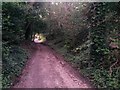
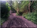
Redhill: Sandy Way is a track at this point
Sandy Way is a lane some 630m in length which forms public bridleway O07 between Wimborne Road and Headswell Avenue. At each end, it is a gravel road with a few dwellings but the majority of it is a very rural feeling track in a steep sided, linear wood.
Here, we are towards the southern end and it is still motorable at this point, as there are a couple of rear garages behind us accessed along here before the track becomes a path through the woods.
See Image for the next view along the route ahead, and Image for the next view behind us - each giving links to further photos all along the route.
Image: © Chris Downer
Taken: 6 Jul 2016
0.10 miles
9
Redhill: last garage access on Sandy Way
Sandy Way is a lane some 630m in length which forms public bridleway O07 between Wimborne Road and Headswell Avenue. At each end, it is a gravel road with a few dwellings but the majority of it is a very rural feeling track in a steep sided, linear wood.
Here, we pass the last access to rear garages of Headswell Avenue (left) as the bridleway bears right into the wooded section.
See Image for the next view along the path ahead, and Image for the next view behind us - each giving links to further photos all along the route.
Image: © Chris Downer
Taken: 6 Jul 2016
0.10 miles
10
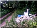
Redhill: fly tipping alongside Sandy Way
Sandy Way is a lane some 630m in length which forms public bridleway O07 between Wimborne Road and Headswell Avenue. At each end, it is a gravel road with a few dwellings but the majority of it is a very rural feeling track in a steep sided, linear wood.
Here, we head north along the section from Headswell Avenue, passing an old freezer and some breeze blocks which have been dumped at the side of the track.
See Image for the next view along the route ahead, and Image for the next view behind us - each giving links to further photos all along the route.
Image: © Chris Downer
Taken: 6 Jul 2016
0.11 miles