IMAGES TAKEN NEAR TO
Delamere Gardens, BOURNEMOUTH, BH10 6AA
Introduction
This page details the photographs taken nearby to Delamere Gardens, BH10 6AA by members of the Geograph project.
The Geograph project started in 2005 with the aim of publishing, organising and preserving representative images for every square kilometre of Great Britain, Ireland and the Isle of Man.

There are currently over 7.5m images from over14,400 individuals and you can help contribute to the project by visiting https://www.geograph.org.uk
Image Map
Images are licensed for reuse under creativecommons.org/licenses/by-sa/2.0
Notes
- Clicking on the map will re-center to the selected point.
- The higher the marker number, the further away the image location is from the centre of the postcode.
Image Listing (91 Images Found)
Images are licensed for reuse under creativecommons.org/licenses/by-sa/2.0
Image
Details
Distance
1
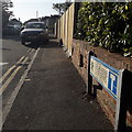
Redhill: Delamere Gardens
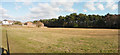
A short dead-end road off Redhill Drive, facing onto Redhill Park which is behind us, across the road. Beyond the back gardens of the houses each side, we can glimpse the desirable detached housing of Delamere Gardens, typical of the area.
The road sign is a standard one from around 2000-2006, perhaps a little earlier, featuring the borough coat of arms. The incorporated no-through-road sign is a common arrangement, and for good measure the message is reinforced with the word CUL-DE-SAC in small type at the bottom.
This is photo no.106 of a series of 453 in my coronavirus lockdown walking project:
See https://www.geograph.org.uk/article/My-2020-Coronavirus-Lockdown-walking-project for the complete set of photos.
Image: © Chris Downer
Taken: 13 Apr 2020
0.02 miles
2
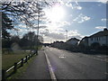
Bournemouth : Redhill Drive
Redhill Drive looking towards the junction with Boundary Road and Redhill Park on the left.
Image: © Lewis Clarke
Taken: 11 Feb 2010
0.06 miles
3
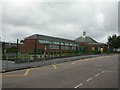
Ensbury Park, Hill View Primary School
On Hill View Road. The original school buildings are at the front, and newer ones at the back (seen to the left). http://www.hillview.bournemouth.sch.uk/introduction/the_school.htm
Image: © Mike Faherty
Taken: 26 Jul 2009
0.06 miles
4
Bournemouth : Redhill Drive
Redhill Drive with a zebra crossing and my shadow.
Image: © Lewis Clarke
Taken: 11 Feb 2010
0.06 miles
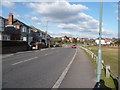
5
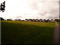
Bournemouth : Grassy Field & Trees
An open space on Redhill Drive. A few houses and trees back onto it.
Image: © Lewis Clarke
Taken: 11 Feb 2010
0.06 miles
6
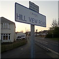
Northbourne: Hill View Road
Often written as two words, Hill View Road is correctly spelled as three. It is seen here from its eastern end, opposite Redhill Common, and it heads past Hill View Primary School and the shopping parade New Parade in this first segment, before arcing to face northwest and come to an end at a dead end, one of the longest dead ends after the last turn-off.
The corner house on the left once housed Redhill Drive Post Office, before it moved into New Parade in the mid-1990s.
The sign is a modern one, from 2010-15 when this more modern, abstract emblem rather than the traditional town coat of arms as the working logo of the council. They are more often seen under perspex and mounted on two posts, but this one is affixed to the tall pole.
This is photo no.200 of a series of 453 in my coronavirus lockdown walking project:
See https://www.geograph.org.uk/article/My-2020-Coronavirus-Lockdown-walking-project for the complete set of photos.
Image: © Chris Downer
Taken: 10 Apr 2020
0.06 miles
7

Bournemouth : Field & Trees
A grassy field beside Redhill Drive.
Image: © Lewis Clarke
Taken: 11 Feb 2010
0.06 miles
8
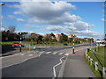
Bournemouth : Redhill Drive Zebra Crossing
A crossing on Redhill Drive which allows people to cross a lot easier.
Image: © Lewis Clarke
Taken: 11 Feb 2010
0.08 miles
9
Redhill: houses face onto Redhill Common
Houses on the western side of Redhill Drive look out onto this grassy part of the common. Immediately behind us we enter a long narrow strip of woodland.
Image: © Chris Downer
Taken: 23 Oct 2010
0.08 miles
10
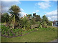
Bournemouth : Floral Display
A display with a boat in the middle on Hill View Road.
Image: © Lewis Clarke
Taken: 11 Feb 2010
0.09 miles