
IMAGES TAKEN NEAR TO
Leybourne Avenue, BOURNEMOUTH, BH10 5NP
Introduction
This page details the photographs taken nearby to Leybourne Avenue, BH10 5NP by members of the Geograph project.
The Geograph project started in 2005 with the aim of publishing, organising and preserving representative images for every square kilometre of Great Britain, Ireland and the Isle of Man.

There are currently over 7.5m images from over14,400 individuals and you can help contribute to the project by visiting https://www.geograph.org.uk
Image Map
Images are licensed for reuse under creativecommons.org/licenses/by-sa/2.0
Notes
- Clicking on the map will re-center to the selected point.
- The higher the marker number, the further away the image location is from the centre of the postcode.
Image Listing (225 Images Found)
Images are licensed for reuse under creativecommons.org/licenses/by-sa/2.0
Image
Details
Distance
1

Northbourne: detached segment of Leybourne Avenue
Leybourne Avenue is a busy suburban road, marked in yellow on the map and apparently coming to an end at the junction of East Howe Lane behind us. However, it continues here, detached although accessible on foot. Vehicles have to go via Long Road to get here.
The area immediately in front of us, with the tyre marks, is actually grassed while the tarmacked carriageway finished just beyond the greenery on the left.
Image: © Chris Downer
Taken: 25 Dec 2010
0.01 miles
2
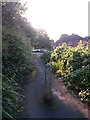
East Howe: footpath E50 approaches the Leybourne Avenue detachment
Looking along this short public footpath as it approaches the detached part of Leybourne Avenue - it arrives here from the main part of Leybourne Avenue, a busy through road.
See Image for a picture looking towards us from the end of the path, and Image] for the next view along the path behind us.
Image: © Chris Downer
Taken: 24 Jun 2016
0.01 miles
3

East Howe: footpath E50 from its western end
Looking along the public footpath linking this detached segment of Leybourne Avenue with the main part of the same Avenue, beyond the trees. See Image] for more discussion on Leybourne Avenue's route.
See Image] for a view towards us from the lamppost in the background.
Image: © Chris Downer
Taken: 24 Jun 2016
0.01 miles
4

East Howe: a grass alternative to footpath E50
Looking along the paved route of the public footpath, it is clear that the route across the grass is commonly used instead.
See Image for a wider view of the path from just behind us, and Image for a photo further along the paved path, as it opens out onto the remainder of Leybourne Avenue.
Image: © Chris Downer
Taken: 5 Jul 2016
0.02 miles
5
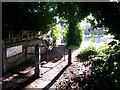
East Howe: footpath E50 from Leybourne Avenue to Leybourne Avenue
Leybourne Avenue behind us is one of the main roads through these northern suburbs. While traffic then turns left or right onto East Howe Lane, there is a continuation of Leybourne Avenue ahead of us, accessible from here only by this public footpath. It is evident from just ahead that the grass patch to the right is commonly used instead of the paved official route of the right of way: see Image
Image: © Chris Downer
Taken: 24 Jun 2016
0.02 miles
6

Northbourne: the stub of Leybourne Avenue
Leybourne Avenue is well known to most locals as a principal route through the northern suburbs of Bournemouth. However, this minor part is separated from the main rat-run and connected to it by a couple of paths. It is a dead-end at both ends and features a large grassed circle, right, with the even-numbered houses running around the far side of it.
See Image for the view towards us from the grass in the distance, left.
Image: © Chris Downer
Taken: 6 Nov 2016
0.04 miles
7
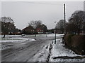
Northbourne: Long Road reaches Leybourne Avenue
We look along the northern end of Long Road (which is not long but probably named after someone named Long) at the tail end of the very cold spell which has lasted all December. The roads are hazardous and the pavements even more so.
It comes out onto a part of Leybourne Avenue, which loops around a grassed area. This part of Leybourne Avenue is separate from the main, busy section which is marked yellow on the map, just to the east. A footpath connects the two parts.
Image: © Chris Downer
Taken: 25 Dec 2010
0.04 miles
8

Northbourne: grassy patch at East Howe Lane/Leybourne Avenue junction
Looking across the staggered junction of East Howe Lane, which is to the left and also continues to the right although not in a straight line. Leybourne Avenue is behind us, and continues beyond the footpath visible on the right.
The snow has lain around these parts for a couple of weeks, the most recent snowfall having happened on Monday. This is possibly the nearest Bournemouth will get to a white Christmas.
Image: © Chris Downer
Taken: 25 Dec 2010
0.04 miles
9

Northbourne: autumnal trees on the stub of Leybourne Avenue
Leybourne Avenue is well known to most locals as a principal route through the northern suburbs of Bournemouth. However, this minor part is separated from the main rat-run and connected to it by a couple of paths. It is a dead-end at both ends and features a large grassed circle, left, with the even-numbered houses running around the far side of it.
Image: © Chris Downer
Taken: 23 Oct 2016
0.05 miles
10
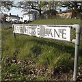
East Howe: East Howe Lane
East Howe Lane is one of the main routes in this part of town. As perhaps suggested by the word Lane, it is one of the original track routes long before Bournemouth's suburbia reached this far. Here, at the Leybourne Avenue junction, the road has been rerouted from its original line, which follows the line of old houses which we see to the right.
East Howe Lane has a wide variety of housing: council housing in two parts, private bungalows in two other parts, old cottages like those pictured here, and even a couple of very old thatched cottages such as Image There aren't many of those in Bournemouth's suburbs!
The sign is of a simple design which was produced in great numbers, I believe at the back end of the 1980s, and quite a few remain. Some, like this one, are beginning to look a little tatty while others look as good as new.
This is photo no.122 of a series of 453 in my coronavirus lockdown walking project:
See https://www.geograph.org.uk/article/My-2020-Coronavirus-Lockdown-walking-project for the complete set of photos.
Image: © Chris Downer
Taken: 10 Apr 2020
0.05 miles