IMAGES TAKEN NEAR TO
Highlands Crescent, BOURNEMOUTH, BH10 5JR
Introduction
This page details the photographs taken nearby to Highlands Crescent, BH10 5JR by members of the Geograph project.
The Geograph project started in 2005 with the aim of publishing, organising and preserving representative images for every square kilometre of Great Britain, Ireland and the Isle of Man.

There are currently over 7.5m images from over14,400 individuals and you can help contribute to the project by visiting https://www.geograph.org.uk
Image Map
Images are licensed for reuse under creativecommons.org/licenses/by-sa/2.0
Notes
- Clicking on the map will re-center to the selected point.
- The higher the marker number, the further away the image location is from the centre of the postcode.
Image Listing (88 Images Found)
Images are licensed for reuse under creativecommons.org/licenses/by-sa/2.0
Image
Details
Distance
1
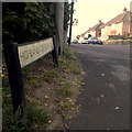
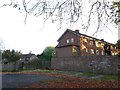
East Howe: Highlands Crescent
One of those 'crescents' that is not actually a crescent but a straightforward dead end – although it does have a semicircular green in its middle at the far end.
It is also unusual in that the house numbering commences at the dead end rather than at the entry.
The sign is from around 2000, and it morphed into another design, in blue rather than green and far more widely seen, including BOURNEMOUTH BOROUGH COUNCIL in smaller letters at the top, and the borough coat of arms on the left.
This is photo no.197 of a series of 453 in my coronavirus lockdown walking project:
See https://www.geograph.org.uk/article/My-2020-Coronavirus-Lockdown-walking-project for the complete set of photos.
Image: © Chris Downer
Taken: 12 Apr 2020
0.05 miles
2
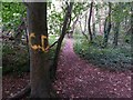
Kinson: my initials, but not my doing
Someone has rather sadly defaced a tree in Kinson Common with the initials CD in yellow paint - this is one of several trees marred by graffiti in this southeast corner of the Common.
Image: © Chris Downer
Taken: 28 Aug 2016
0.06 miles
3
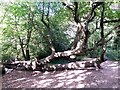
Kinson: large fallen tree on Kinson Common
This large tree has been horizontal for many years - indeed, there are actually two similar trees here. A blue rope, for fun use as a swing, might just be seen towards the right-hand side of the picture - it is hanging from the second tree.
Image: © Chris Downer
Taken: 9 Oct 2016
0.06 miles
4
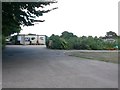
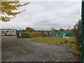
Kinson: Brook Road allotments
This is as much of a view as one can get, the camera pointing through the ironwork of the large main gates. The allotments cover quite a large triangular area, but are hidden by a tall hedgerow on the eastern side, and hemmed in by housing on the west and north sides.
Image: © Chris Downer
Taken: 29 Aug 2016
0.06 miles
5
Kinson: Black Balls and other graffiti
A disused, tarmacked yard behind a block of flats in Brook Road is daubed with graffiti on its retaining wall. Meanwhile, the upper-floor flats catch the last of the sunshine on this November late-afternoon.
Image: © Chris Downer
Taken: 6 Nov 2016
0.06 miles
6
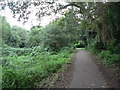
West Howe: path from Kinson Common
The path south from Kinson Common, which also incorporates a shared cycleway between Kinson Road and Poole Lane, on the route shown by the black dotted line on the map.
Image: © Chris Downer
Taken: 17 Aug 2008
0.07 miles
7
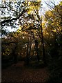
Kinson: darkly under autumn colour in the woods
A path along the linear wooded stretch of Kinson Common is in relative darkness late-afternoon in November, despite the sunshine. The tops of the trees do catch the sunlight, though, with pretty autumn yellows and oranges on display.
Image: © Chris Downer
Taken: 6 Nov 2016
0.07 miles
8

East Howe: footpath E56 reaches Kinson Road
This public footpath runs alongside the edge of Kinson Common on this northern leg, and is seen here meeting Kinson Road, along with a path onto the common (sharp left).
See Image for the next photo on the path behind us, with further links to pictures along the route to South Kinson Drive.
Image: © Chris Downer
Taken: 12 Jul 2016
0.08 miles
9
Kinson: another view of Brook Road allotments
A similar picture to Image, through the gates but looking a bit further round to the right to see more of the plots and less of the building.
Image: © Chris Downer
Taken: 20 Nov 2016
0.08 miles
10
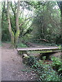
Kinson: small footbridge on the common
A small wooden footbridge in the wooded area of Kinson Common.
Image: © Chris Downer
Taken: 17 Aug 2008
0.08 miles