
IMAGES TAKEN NEAR TO
Lewis Gardens, BOURNEMOUTH, BH10 5ER
Introduction
This page details the photographs taken nearby to Lewis Gardens, BH10 5ER by members of the Geograph project.
The Geograph project started in 2005 with the aim of publishing, organising and preserving representative images for every square kilometre of Great Britain, Ireland and the Isle of Man.

There are currently over 7.5m images from over14,400 individuals and you can help contribute to the project by visiting https://www.geograph.org.uk
Image Map
Images are licensed for reuse under creativecommons.org/licenses/by-sa/2.0
Notes
- Clicking on the map will re-center to the selected point.
- The higher the marker number, the further away the image location is from the centre of the postcode.
Image Listing (108 Images Found)
Images are licensed for reuse under creativecommons.org/licenses/by-sa/2.0
Image
Details
Distance
1
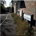
Ensbury Park: Lewis Gardens
An infill development of bungalows, something that has happened a lot in Ensbury Park over the last 20 years, off Howeth Road. It is not on the 2007 edition of the local A-Z street plan but appears in 2009.
The sign is a modern one, from 2010-15 when this more modern, abstract emblem rather than the traditional town coat of arms as the working logo of the council.
This is photo no.241 of a series of 453 in my coronavirus lockdown walking project:
See https://www.geograph.org.uk/article/My-2020-Coronavirus-Lockdown-walking-project for the complete set of photos.
Image: © Chris Downer
Taken: 13 Apr 2020
0.02 miles
2
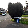
Ensbury Park: Greaves Close
A cul-de-sac off Stanton Road, itself a no-through road, containing these typical 1970s houses, semi-detached on the left and detached on the right and at the end.
The sign is the standard Bournemouth nameplate from the 1980s, affixed with tubular steel which protrudes at each side. The arrangement here, with a full-size no-through-road sign on a short pole, with the nameplate overarching it, was quite common at the time in Bournemouth and a few like this survive, but I'm not sure that I've ever seen it elsewhere.
This is photo no.172 of a series of 453 in my coronavirus lockdown walking project:
See https://www.geograph.org.uk/article/My-2020-Coronavirus-Lockdown-walking-project for the complete set of photos.
Image: © Chris Downer
Taken: 19 Apr 2020
0.07 miles
3
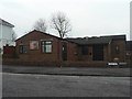
Ensbury Park: Howeth Road Evangelical Church
Situated on the staggered crossroads of Howeth and Kingswell Roads.
Image: © Chris Downer
Taken: 24 Feb 2008
0.07 miles
4
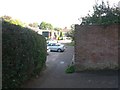
East Howe: Stanton Road from Learning Lane
A short path - literally only a couple of yards in length, arrives here on Learning Lane from the dead-end of Stanton Road. See Image] for more information on Learning Lane.
Image: © Chris Downer
Taken: 7 Jun 2016
0.07 miles
5
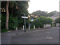
East Howe: Learning Lane from Heather Road
This public footpath, numbered U39, leads from Heather Road to Hadow Road via the dead end of Green Lane. Here, we see it at its eastern end.
In recent years, it has been marked as a shared foot/cycle route.
Many of the footpaths on the West Howe estate and thereabouts have been given names in the last couple of years, a safety initiative whose intention is that, in the event of calling for help, one's location can be more easily described. This one has been named Learning Lane, no doubt because it leads to Hadow Road, where the area's primary and secondary schools are located.
See Image for the next view along the path.
Image: © Chris Downer
Taken: 3 Jul 2016
0.08 miles
6
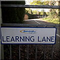
East Howe: Learning Lane
Looking along this public footpath from Heather Road to Hadow Road, from the point midway along where it meets Green Lane. Many of the footpaths on the West Howe estate and thereabouts have been given names in the last couple of years, a safety initiative whose intention is that, in the event of calling for help, one's location can be more easily described. This one has been named Learning Lane, no doubt because it leads to Hadow Road, where the area's primary and secondary schools are located.
See Image for more discussion and links to further photos along the route of the path.
The sign is a modern one, from 2010-15 when this more modern, abstract emblem rather than the traditional town coat of arms as the working logo of the council.
This is photo no.239 of a series of 453 in my coronavirus lockdown walking project:
See https://www.geograph.org.uk/article/My-2020-Coronavirus-Lockdown-walking-project for the complete set of photos.
Image: © Chris Downer
Taken: 11 Apr 2020
0.08 miles
7
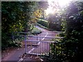
East Howe: triple barrier on Learning Lane
Three, rather than the usual two, railings form a barrier on this public footpath, U39, between Heather Road and Green Lane. It is no doubt intended to prevent high-speed cycling on what has, in recent years, been marked out as a shared foot/cycle route.
Many of the footpaths on the West Howe estate and thereabouts have been given names in the last couple of years, a safety initiative whose intention is that, in the event of calling for help, one's location can be more easily described. This one has been named Learning Lane, no doubt because it leads to Hadow Road, where the area's primary and secondary schools are located.
See Image for the next view along the path ahead, and Image for the start of the path behind us.
Image: © Chris Downer
Taken: 3 Jul 2016
0.08 miles
8
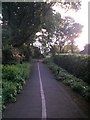
East Howe: approaching Green Lane from Heather Road on footpath U39
This public footpath has, in recent years, been marked out as a shared foot/cycle route. It leads from Heather Road to Hadow Road, via Green Lane whose dead end we see ahead.
Many of the footpaths on the West Howe estate and thereabouts have been given names in the last couple of years, a safety initiative whose intention is that, in the event of calling for help, one's location can be more easily described. This one has been named Learning Lane, no doubt because it leads to Hadow Road, where the area's primary and secondary schools are located.
See Image for the view towards us from ahead - and links to the continuing route to Hadow Road, and Image for the next picture along the path behind us.
Image: © Chris Downer
Taken: 3 Jul 2016
0.08 miles
9
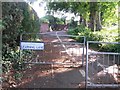
East Howe: footpath U39 heads for Hadow Road
This public footpath has, in recent years, been marked out as a shared foot/cycle route. We see it here from its midway point, heading west-ish to Hadow Road - but it also continues left just behind us, towards Heather Road.
Many of the footpaths on the West Howe estate and thereabouts have been given names in the last couple of years, a safety initiative whose intention is that, in the event of calling for help, one's location can be more easily described. This one has been named Learning Lane, no doubt because it leads to Hadow Road, where the area's primary and secondary schools are located.
See Image for the view from the Hadow Road end of the path (ahead), and Image for a view along the other segment of the path to the left.
Image: © Chris Downer
Taken: 7 Jun 2016
0.08 miles
10
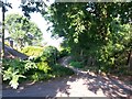
East Howe: heading to Heather Road on footpath U39
This public footpath has, in recent years, been marked out as a shared foot/cycle route. We see it here from its midway point, heading east to Heather Road - but it also heads right from here, behind us towards Hadow Road.
Many of the footpaths on the West Howe estate and thereabouts have been given names in the last couple of years, a safety initiative whose intention is that, in the event of calling for help, one's location can be more easily described. This one has been named Learning Lane, no doubt because it leads to Hadow Road, where the area's primary and secondary schools are located.
See Image for the view towards us from the path ahead, and Image for a view along the path to the right.
Image: © Chris Downer
Taken: 7 Jun 2016
0.09 miles