IMAGES TAKEN NEAR TO
Mabey Avenue, BOURNEMOUTH, BH10 5DT
Introduction
This page details the photographs taken nearby to Mabey Avenue, BH10 5DT by members of the Geograph project.
The Geograph project started in 2005 with the aim of publishing, organising and preserving representative images for every square kilometre of Great Britain, Ireland and the Isle of Man.

There are currently over 7.5m images from over14,400 individuals and you can help contribute to the project by visiting https://www.geograph.org.uk
Image Map
Images are licensed for reuse under creativecommons.org/licenses/by-sa/2.0
Notes
- Clicking on the map will re-center to the selected point.
- The higher the marker number, the further away the image location is from the centre of the postcode.
Image Listing (135 Images Found)
Images are licensed for reuse under creativecommons.org/licenses/by-sa/2.0
Image
Details
Distance
1
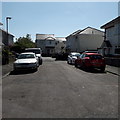
Ensbury Park: the dead end of Mabey Avenue
Mabey Avenue is a traditional little dead-end street off Kingswell Road, but continuing off the end, ahead, is a newly built infill named Carter Close.
There has been much infill development within Bournemouth's suburbs in recent years, especially around here in Ensbury Park.
Carter Close appears to be part of a larger development, with each segment accessible from a different road, so each bit appears to a minuscule site.
Image: © Chris Downer
Taken: 14 Apr 2020
0.02 miles
2
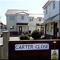
Ensbury Park: Carter Close
Carter Close is not so much a road in its own right, but more of a forecourt extending the dead end of Mabey Avenue. It is better appreciated from a wider view: Image
It is one example of much infill development in many pockets of Ensbury Park. This one pocket includes Kings Close, which is accessed from Columbia Road, and there is apparently no access between the two.
The sign is a modern one which seems to be council-made although it uses the Trebuchet typeface which the council ditched for its standard signs several years before the development was built.
This is photo no.61 of a series of 453 in my coronavirus lockdown walking project:
See https://www.geograph.org.uk/article/My-2020-Coronavirus-Lockdown-walking-project for the complete set of photos.
Image: © Chris Downer
Taken: 14 Apr 2020
0.03 miles
3
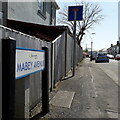
Ensbury Park: Mabey Avenue
There are quite a few dead ends off Kingswell Road, but Mabey Avenue is the only one which was built at the same time: all the others are developments from perhaps the 1970s up to the present day.
The sign is a modern one, from 2010-15 when this more modern, abstract emblem rather than the traditional town coat of arms as the working logo of the council. The no-through-road sign incorporated into the nameplate is a common arrangement.
This is photo no.252 of a series of 453 in my coronavirus lockdown walking project:
See https://www.geograph.org.uk/article/My-2020-Coronavirus-Lockdown-walking-project for the complete set of photos.
Image: © Chris Downer
Taken: 14 Apr 2020
0.03 miles
4
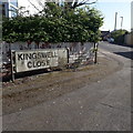
Ensbury Park: Kingswell Close
One of three offshoots of Kingswell Road that share its first name, Gardens and Grove being the other two.
The sign is the standard Bournemouth nameplate from the 1980s, affixed with tubular steel which protrudes at each side, with a (faded) no-through-road sign incorporated into it.
This is photo no.225 of a series of 453 in my coronavirus lockdown walking project:
See https://www.geograph.org.uk/article/My-2020-Coronavirus-Lockdown-walking-project for the complete set of photos.
Image: © Chris Downer
Taken: 13 Apr 2020
0.04 miles
5
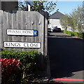
Ensbury Park: Kings Close
Modern infill development of which there are many examples in Ensbury Park. This particular part has been particularly densely infilled, with Kings Close backing onto Carter Close, Newmill Close and Orchard Close, all within the same section of original back gardens but none accessible from any of the others.
The sign is akin to a council-supplied one but does not match the design of any Bournemouth ones, so it has probably been erected by the developer.
This is photo no.224 of a series of 453 in my coronavirus lockdown walking project:
See https://www.geograph.org.uk/article/My-2020-Coronavirus-Lockdown-walking-project for the complete set of photos.
Image: © Chris Downer
Taken: 13 Apr 2020
0.04 miles
6
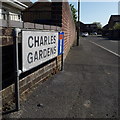
Ensbury Park: Charles Gardens
An early- or mid-1980s development off Kingswell Road, eating into the surrounding back gardens – an early forerunner of the much similar infill development that has occurred hereabouts in recent years.
The sign is the standard Bournemouth nameplate from the 1980s, affixed with tubular steel which protrudes at each side. For cul-de-sacs, it is common for these to incorporate the no-through road sign, as here.
This is photo no.67 of a series of 453 in my coronavirus lockdown walking project:
See https://www.geograph.org.uk/article/My-2020-Coronavirus-Lockdown-walking-project for the complete set of photos.
Image: © Chris Downer
Taken: 13 Apr 2020
0.05 miles
7
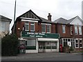
Ensbury Park: post office
Situated at 137 Columbia Road.
Image: © Chris Downer
Taken: 3 Feb 2008
0.06 miles
8
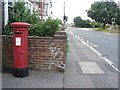
Ensbury Park: postbox № BH10 198, Columbia Road
This postbox stands outside the frontage of Image
Image: © Chris Downer
Taken: 6 Jul 2008
0.06 miles
9
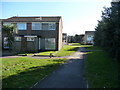
Bournemouth : Path & Houses
Just off Columbia Road this path leads towards Archdale Close and Jubilee Gardens.
Image: © Lewis Clarke
Taken: 8 Mar 2010
0.06 miles
10
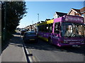
Bournemouth : Columbia Road & Training Bus
A bus training for what could possibly be the 5b route which passes through here.
Image: © Lewis Clarke
Taken: 8 Mar 2010
0.07 miles