IMAGES TAKEN NEAR TO
Columbia Road, BOURNEMOUTH, BH10 4GE
Introduction
This page details the photographs taken nearby to Columbia Road, BH10 4GE by members of the Geograph project.
The Geograph project started in 2005 with the aim of publishing, organising and preserving representative images for every square kilometre of Great Britain, Ireland and the Isle of Man.

There are currently over 7.5m images from over14,400 individuals and you can help contribute to the project by visiting https://www.geograph.org.uk
Image Map
Images are licensed for reuse under creativecommons.org/licenses/by-sa/2.0
Notes
- Clicking on the map will re-center to the selected point.
- The higher the marker number, the further away the image location is from the centre of the postcode.
Image Listing (113 Images Found)
Images are licensed for reuse under creativecommons.org/licenses/by-sa/2.0
Image
Details
Distance
1
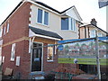
Bournemouth : Housing Construction
This house looks almost ready to be snapped up on the property market.
Image: © Lewis Clarke
Taken: 8 Mar 2010
0.02 miles
2
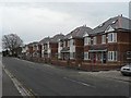
Ensbury Park: new homes aplenty
A line of new houses in Columbia Road, which replaced the perfectly serviceable dwellings that had stood here till recently. This development also includes a row of houses behind, in what had been the gardens of the previous buildings.
Image: © Chris Downer
Taken: 3 Feb 2008
0.03 miles
3
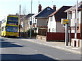
Bournemouth : Columbia Road, 5a Yellow Bus
A 5a Yellow Bus service makes its way into town - let's hope it doesn't get caught by that intimidating speed camera.
Image: © Lewis Clarke
Taken: 8 Mar 2010
0.03 miles
4
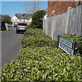
Ensbury Park: Columbia Gardens
Modern infill off Columbia Road, as is plentiful in the Ensbury Park area, Columbia Gardens is one of those roads that looks more like a driveway because the original kerbstones on the major road are still in place, but lowered as for an ordinary domestic drive.
The sign looks like an official one but does not have the borough logo which would normally be seen on signs like these. A further plate saying PRIVATE ROAD is an afterthought.
This is photo no.75 of a series of 453 in my coronavirus lockdown walking project:
See https://www.geograph.org.uk/article/My-2020-Coronavirus-Lockdown-walking-project for the complete set of photos.
Image: © Chris Downer
Taken: 14 Apr 2020
0.03 miles
5
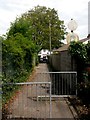
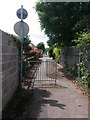
Ensbury Park: Furze Bank Lane nears Columbia Road
Looking along this public footpath which is one of three such segments of Furze Bank Lane. This northern segment is footpath N07 and it is seen here approaching Columbia Road.
Motor vehicles are not allowed beyond this point; the reason they can drive this far is that there is a garage access for one of the few houses in the lane.
See Image for the view up the lane from Columbia Road, and Image for the view behind us from these railings.
Image: © Chris Downer
Taken: 9 Jul 2016
0.04 miles
6
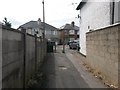
East Howe: footpath U33 from Columbia Road
This public footpath leads to Kingswell Road, crossing Heaton Road on the way.
See Image for the view along the end of the path towards us, and links to further photos along the route.
Image: © Chris Downer
Taken: 9 Jul 2016
0.04 miles
7
East Howe: footpath U33 arrives at Columbia Road
This public footpath from Kingswell and Heaton Roads reaches its destination - the opposite view to Image
See Image for the next view along the path behind us, and further links to photos along the route.
Image: © Chris Downer
Taken: 9 Jul 2016
0.04 miles
8
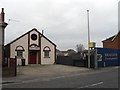
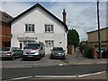
Ensbury Park: Unity Hall
The headquarters of the local Labour Party, for both constituencies (Bournemouth East and Bournemouth West), this hall was due for closure, demolition and replacement by flats – a fate that has recently befallen the neighbouring site – according to the local paper but this was vehementy denied by the owners.
Image: © Chris Downer
Taken: 3 Feb 2008
0.05 miles
9
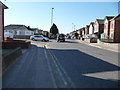
Bournemouth : Columbia Road
Looking down Columbia Road towards Kinson Road, and on the left a road junction with Priestley Road.
Image: © Lewis Clarke
Taken: 8 Mar 2010
0.05 miles
10
Ensbury Park: Furze Bank Lane heads south
Looking along this public footpath which is one of three such segments of Furze Bank Lane. This northern segment is footpath N07 and it is seen here just after leaving Columbia Road.
The railings are halfway down the path because beyond them is access to a driveway from Cove Road ahead.
See Image for the next view along the path, as it crosses Cove Road, and Image for the view behind us from these railings.
Image: © Chris Downer
Taken: 9 Jul 2016
0.05 miles