IMAGES TAKEN NEAR TO
Great Horton Road, BRADFORD, BD7 4LT
Introduction
This page details the photographs taken nearby to Great Horton Road, BD7 4LT by members of the Geograph project.
The Geograph project started in 2005 with the aim of publishing, organising and preserving representative images for every square kilometre of Great Britain, Ireland and the Isle of Man.

There are currently over 7.5m images from over14,400 individuals and you can help contribute to the project by visiting https://www.geograph.org.uk
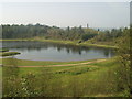
Image Map
Images are licensed for reuse under creativecommons.org/licenses/by-sa/2.0
Notes
- Clicking on the map will re-center to the selected point.
- The higher the marker number, the further away the image location is from the centre of the postcode.
Image Listing (73 Images Found)
Images are licensed for reuse under creativecommons.org/licenses/by-sa/2.0
Image
Details
Distance
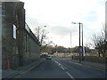
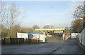
2
Beacon Road
The mill complex on the right was built in 1864.
Image: © Betty Longbottom
Taken: 3 Nov 2007
0.03 miles
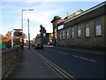
3
The Hare and Hounds and Beacon Road, Great Horton
Beacon Road is the B6380 from the A647 to the A641 at Odsal Top.
Image: © Humphrey Bolton
Taken: 19 Aug 2010
0.03 miles
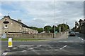
7
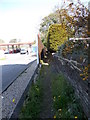
Footpath - Beacon Road to Great Horton Road
Image: © Betty Longbottom
Taken: 22 May 2012
0.05 miles
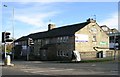
8
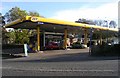
Jet Filling Station - Great Horton Road
Image: © Betty Longbottom
Taken: 3 Nov 2007
0.06 miles
10
Bray Close - off Great Horton Road
Image: © Betty Longbottom
Taken: 22 May 2012
0.08 miles