IMAGES TAKEN NEAR TO
Esmond Street, BRADFORD, BD7 4DX
Introduction
This page details the photographs taken nearby to Esmond Street, BD7 4DX by members of the Geograph project.
The Geograph project started in 2005 with the aim of publishing, organising and preserving representative images for every square kilometre of Great Britain, Ireland and the Isle of Man.

There are currently over 7.5m images from over14,400 individuals and you can help contribute to the project by visiting https://www.geograph.org.uk
Image Map
Images are licensed for reuse under creativecommons.org/licenses/by-sa/2.0
Notes
- Clicking on the map will re-center to the selected point.
- The higher the marker number, the further away the image location is from the centre of the postcode.
Image Listing (93 Images Found)
Images are licensed for reuse under creativecommons.org/licenses/by-sa/2.0
Image
Details
Distance
3
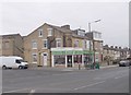
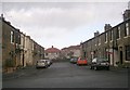
Norland Street - Great Horton Road
Image: © Betty Longbottom
Taken: 17 Dec 2008
0.02 miles
4
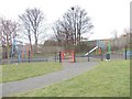
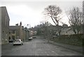
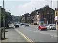
Bartle Place, Bradford
Short street in the Great Horton area of Bradford.
Image: © Chris Heaton
Taken: 26 Aug 2016
0.04 miles
7
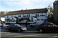
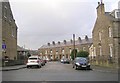
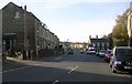
Great Horton Road
A view up the hill towards Horton Bank Top. This is the A647 leading to Queensbury and Halifax.
Image: © David Spencer
Taken: 12 Jul 2005
0.08 miles