IMAGES TAKEN NEAR TO
Ewart Place, BRADFORD, BD7 3PD
Introduction
This page details the photographs taken nearby to Ewart Place, BD7 3PD by members of the Geograph project.
The Geograph project started in 2005 with the aim of publishing, organising and preserving representative images for every square kilometre of Great Britain, Ireland and the Isle of Man.

There are currently over 7.5m images from over14,400 individuals and you can help contribute to the project by visiting https://www.geograph.org.uk
Image Map
Images are licensed for reuse under creativecommons.org/licenses/by-sa/2.0
Notes
- Clicking on the map will re-center to the selected point.
- The higher the marker number, the further away the image location is from the centre of the postcode.
Image Listing (120 Images Found)
Images are licensed for reuse under creativecommons.org/licenses/by-sa/2.0
Image
Details
Distance
4
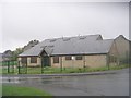
Great Horton Village Hall - Belton Close
Image: © Betty Longbottom
Taken: 11 Oct 2011
0.04 miles
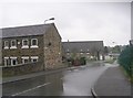
8
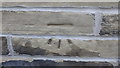
OS Cut Benchmark, Beldon Road
This is on a high wall at the corner of Beldon Road & Ward Street. Details at http://www.bench-marks.org.uk/bm92006
Image: © Stephen Armstrong
Taken: 4 Nov 2017
0.05 miles
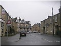
9
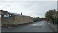
Beldon Road from the junction with Ward Street
There is an OS Cut Benchmark on the wall at the corner with Ward Street. See Image
Image: © Stephen Armstrong
Taken: 4 Nov 2017
0.05 miles