IMAGES TAKEN NEAR TO
Southfield Lane, BRADFORD, BD7 3NL
Introduction
This page details the photographs taken nearby to Southfield Lane, BD7 3NL by members of the Geograph project.
The Geograph project started in 2005 with the aim of publishing, organising and preserving representative images for every square kilometre of Great Britain, Ireland and the Isle of Man.

There are currently over 7.5m images from over14,400 individuals and you can help contribute to the project by visiting https://www.geograph.org.uk
Image Map
Images are licensed for reuse under creativecommons.org/licenses/by-sa/2.0
Notes
- Clicking on the map will re-center to the selected point.
- The higher the marker number, the further away the image location is from the centre of the postcode.
Image Listing (143 Images Found)
Images are licensed for reuse under creativecommons.org/licenses/by-sa/2.0
Image
Details
Distance
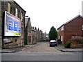
2
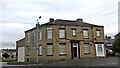
Former Southfield Hotel, Southfield Lane, Bradford
Converted to residential use in 2015. Looking rather dull with the black paintwork, compared to how it looked in 2008 when it was still a pub. Image
Image: © Stephen Armstrong
Taken: 11 Nov 2017
0.03 miles
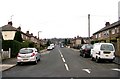
5
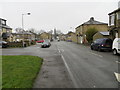
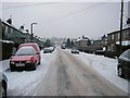
Southfield Lane, Bradford - BD7
Looking north-westward.
Image: © Peter Wood
Taken: 27 Dec 2019
0.03 miles
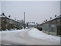
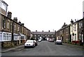
6
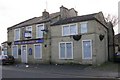
Low Green Terrace - Southfield Lane
Image: © Betty Longbottom
Taken: 23 Dec 2008
0.04 miles
8
Southmere Crescent - Southmere Road
Image: © Betty Longbottom
Taken: 23 Dec 2008
0.05 miles
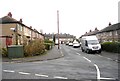
10
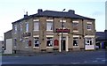
Stephenson Street - Low Green Terrace
Image: © Betty Longbottom
Taken: 23 Dec 2008
0.05 miles