IMAGES TAKEN NEAR TO
Hudson Avenue, BRADFORD, BD7 3ND
Introduction
This page details the photographs taken nearby to Hudson Avenue, BD7 3ND by members of the Geograph project.
The Geograph project started in 2005 with the aim of publishing, organising and preserving representative images for every square kilometre of Great Britain, Ireland and the Isle of Man.

There are currently over 7.5m images from over14,400 individuals and you can help contribute to the project by visiting https://www.geograph.org.uk
Image Map
Images are licensed for reuse under creativecommons.org/licenses/by-sa/2.0
Notes
- Clicking on the map will re-center to the selected point.
- The higher the marker number, the further away the image location is from the centre of the postcode.
Image Listing (103 Images Found)
Images are licensed for reuse under creativecommons.org/licenses/by-sa/2.0
Image
Details
Distance
2
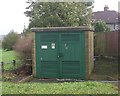
Electricity Substation No 567 - Hudson Avenue
Image: © Betty Longbottom
Taken: 11 Oct 2011
0.04 miles
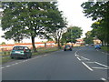
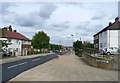
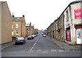
4
Hudson Avenue, Little Horton
This is the Bradford outer ring road, the A6177, not the fastest of routes.
Image: © Humphrey Bolton
Taken: 19 Aug 2010
0.04 miles
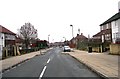
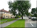
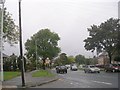
5
Melba Road, Little Horton
Seen from Hudson Avenue.
Image: © Humphrey Bolton
Taken: 19 Aug 2010
0.04 miles
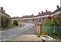
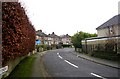
9
Hudson Avenue - off Southfield Lane
Image: © Betty Longbottom
Taken: 11 Oct 2011
0.08 miles