IMAGES TAKEN NEAR TO
Cross Lane, BRADFORD, BD7 3LA
Introduction
This page details the photographs taken nearby to Cross Lane, BD7 3LA by members of the Geograph project.
The Geograph project started in 2005 with the aim of publishing, organising and preserving representative images for every square kilometre of Great Britain, Ireland and the Isle of Man.

There are currently over 7.5m images from over14,400 individuals and you can help contribute to the project by visiting https://www.geograph.org.uk
Image Map
Images are licensed for reuse under creativecommons.org/licenses/by-sa/2.0
Notes
- Clicking on the map will re-center to the selected point.
- The higher the marker number, the further away the image location is from the centre of the postcode.
Image Listing (144 Images Found)
Images are licensed for reuse under creativecommons.org/licenses/by-sa/2.0
Image
Details
Distance
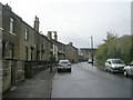
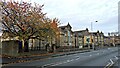
3

The Ridge Medical Centre, Great Horton
With some old houses behind.
Image: © Humphrey Bolton
Taken: 19 Aug 2010
0.04 miles
4
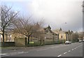
St Oswald's C of E Primary School - Cross Lane
Image: © Betty Longbottom
Taken: 17 Dec 2008
0.05 miles
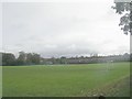
6
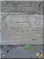
Ordnance Survey Cut Mark
This can be found on a roadside wall at Cross Lane School.
For more detail see : http://www.bench-marks.org.uk/bm24502
Image: © Peter Wood
Taken: 7 Oct 2013
0.06 miles
7
St. Oswald Primary School, Cross Lane, Bradford
Image: © Stephen Armstrong
Taken: 11 Nov 2017
0.06 miles
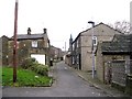
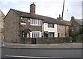
10
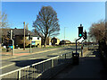
Cross Lane (A6177), Great Horton, Bradford
Image: © habiloid
Taken: 19 Mar 2022
0.06 miles