IMAGES TAKEN NEAR TO
Scholemoor Avenue, BRADFORD, BD7 2RX
Introduction
This page details the photographs taken nearby to Scholemoor Avenue, BD7 2RX by members of the Geograph project.
The Geograph project started in 2005 with the aim of publishing, organising and preserving representative images for every square kilometre of Great Britain, Ireland and the Isle of Man.

There are currently over 7.5m images from over14,400 individuals and you can help contribute to the project by visiting https://www.geograph.org.uk
Image Map
Images are licensed for reuse under creativecommons.org/licenses/by-sa/2.0
Notes
- Clicking on the map will re-center to the selected point.
- The higher the marker number, the further away the image location is from the centre of the postcode.
Image Listing (76 Images Found)
Images are licensed for reuse under creativecommons.org/licenses/by-sa/2.0
Image
Details
Distance
6
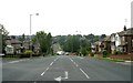
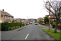
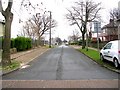
Clayton Road looking towards Bradford Road, Clayton
Image: © Betty Longbottom
Taken: 17 Sep 2008
0.06 miles
7
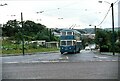
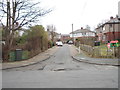
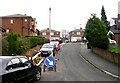
Bradford trolleybus 785 on Pasture Lane ? 1971
July 31st 1971 saw a major step in the abandonment of trolleybus operation in Bradford with the conversion of the Wibsey (46), Buttershaw (45) and Clayton/Pasture Lane (37/38) routes to motorbus operation.
Trolleybus 785 is one of 9 Karrier W vehicles of 1944 purchased from Darlington Corporation when its trolleybus network closed. It received a new East Lancs double-deck body before entering service in Bradford in 1959. It is seen at the top of Pasture Lane about to turn onto Clayton Road and head for the city centre.
The bridge behind formerly carried the former Great Northern Railway branch line from Bradford to Keighley and Halifax which had closed to all traffic in 1965.
This is one of a series of views featuring buses in the 60s, 70s, and 80s. http://www.geograph.org.uk/search.php?i=2114547&displayclass=slide
Image: © Alan Murray-Rust
Taken: 31 Jul 1971
0.06 miles