IMAGES TAKEN NEAR TO
Brooksbank Avenue, BRADFORD, BD7 2RT
Introduction
This page details the photographs taken nearby to Brooksbank Avenue, BD7 2RT by members of the Geograph project.
The Geograph project started in 2005 with the aim of publishing, organising and preserving representative images for every square kilometre of Great Britain, Ireland and the Isle of Man.

There are currently over 7.5m images from over14,400 individuals and you can help contribute to the project by visiting https://www.geograph.org.uk
Image Map
Images are licensed for reuse under creativecommons.org/licenses/by-sa/2.0
Notes
- Clicking on the map will re-center to the selected point.
- The higher the marker number, the further away the image location is from the centre of the postcode.
Image Listing (51 Images Found)
Images are licensed for reuse under creativecommons.org/licenses/by-sa/2.0
Image
Details
Distance
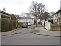
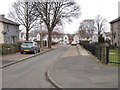
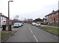
1
Looking back along Brooksbank Avenue
Image: © Betty Longbottom
Taken: 14 Feb 2012
0.04 miles
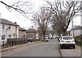
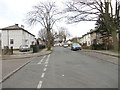
2
Brooksbank Avenue - ending in Footpath
Image: © Betty Longbottom
Taken: 14 Feb 2012
0.05 miles
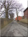
3
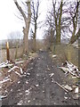
Gateway to public footpath
This path is a muddy track following the cemetery wall. The track and adjoining field are used as a rubbish dump.
Image: © Humphrey Bolton
Taken: 4 Feb 2013
0.05 miles
5
Brooksbank Avenue - viewed from Ashton Avenue
Image: © Betty Longbottom
Taken: 14 Feb 2012
0.06 miles
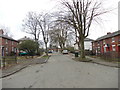
6
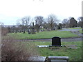
Scholemoor Cemetery - viewed from Brooksbank Avenue
Image: © Betty Longbottom
Taken: 14 Feb 2012
0.07 miles
9
Scholemoor Avenue - viewed from Brooksbank Avenue
Image: © Betty Longbottom
Taken: 14 Feb 2012
0.09 miles