IMAGES TAKEN NEAR TO
Clayton Road, BRADFORD, BD7 2RB
Introduction
This page details the photographs taken nearby to Clayton Road, BD7 2RB by members of the Geograph project.
The Geograph project started in 2005 with the aim of publishing, organising and preserving representative images for every square kilometre of Great Britain, Ireland and the Isle of Man.

There are currently over 7.5m images from over14,400 individuals and you can help contribute to the project by visiting https://www.geograph.org.uk
Image Map
Images are licensed for reuse under creativecommons.org/licenses/by-sa/2.0
Notes
- Clicking on the map will re-center to the selected point.
- The higher the marker number, the further away the image location is from the centre of the postcode.
Image Listing (75 Images Found)
Images are licensed for reuse under creativecommons.org/licenses/by-sa/2.0
Image
Details
Distance
2
Waste land, Clayton Road, Paradise Green, Bradford
The site of the demolished Fields factory.
Image: © habiloid
Taken: 2 Aug 2014
0.05 miles
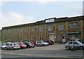
6
Factory, Clayton Road, Great Horton
The stepped parapet on the top of the façade is perhaps distantly related to a Classical pediment.
Image: © Humphrey Bolton
Taken: 19 Aug 2010
0.06 miles
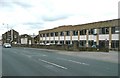
7

Fish and Chip shop, Clayton Road, Great Horton
Sited next to a large factory.
Image: © Humphrey Bolton
Taken: 19 Aug 2010
0.06 miles