IMAGES TAKEN NEAR TO
Turner Avenue, BRADFORD, BD7 2PX
Introduction
This page details the photographs taken nearby to Turner Avenue, BD7 2PX by members of the Geograph project.
The Geograph project started in 2005 with the aim of publishing, organising and preserving representative images for every square kilometre of Great Britain, Ireland and the Isle of Man.

There are currently over 7.5m images from over14,400 individuals and you can help contribute to the project by visiting https://www.geograph.org.uk
Image Map
Images are licensed for reuse under creativecommons.org/licenses/by-sa/2.0
Notes
- Clicking on the map will re-center to the selected point.
- The higher the marker number, the further away the image location is from the centre of the postcode.
Image Listing (91 Images Found)
Images are licensed for reuse under creativecommons.org/licenses/by-sa/2.0
Image
Details
Distance
1
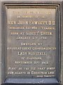
Plaque - New Testament Church of God - Necropolis Rd
This plaque is situated on the wall near the front entrance to the chapel.
Image: © Betty Longbottom
Taken: 5 Jun 2007
0.03 miles
2
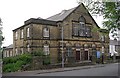
New Testament Church of God - Necropolis Road
Formerly a Methodist Chapel
Image: © Betty Longbottom
Taken: 5 Jun 2007
0.03 miles
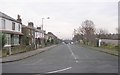
7
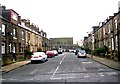
Lidget Avenue - Springfield Avenue
Image: © Betty Longbottom
Taken: 24 Dec 2008
0.08 miles
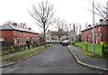
8
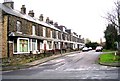
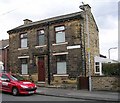
Longford Terrace - Scholemoor Road
Image: © Betty Longbottom
Taken: 24 Dec 2008
0.08 miles
10
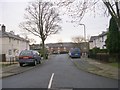
Lidget Avenue - Springfield Avenue
Image: © Betty Longbottom
Taken: 24 Dec 2008
0.09 miles