IMAGES TAKEN NEAR TO
Manorley Lane, BRADFORD, BD6 2TT
Introduction
This page details the photographs taken nearby to Manorley Lane, BD6 2TT by members of the Geograph project.
The Geograph project started in 2005 with the aim of publishing, organising and preserving representative images for every square kilometre of Great Britain, Ireland and the Isle of Man.

There are currently over 7.5m images from over14,400 individuals and you can help contribute to the project by visiting https://www.geograph.org.uk
Image Map (Loading...)


Getting Data...Please wait
Leaflet Map data © OpenStreetMap
Images are licensed for reuse under creativecommons.org/licenses/by-sa/2.0
Notes
- Clicking on the map will re-center to the selected point.
- The higher the marker number, the further away the image location is from the centre of the postcode.
Image Listing (97 Images Found)
Images are licensed for reuse under creativecommons.org/licenses/by-sa/2.0
Image
Details
Distance
3
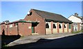
Beckhill Social Club - Manorley Lane
Image: © Betty Longbottom
Taken: 30 Oct 2007
0.05 miles
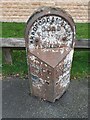
5
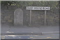
Old Boundary Marker by the A6036, Carr House Road, Halifax Parish
Parish Boundary Marker by the A6036, in parish of Halifax (Calderdale District), Carr House Road, against stone wall and beside road sign for Carr House Road.
To be surveyed
Milestone Society National ID: YW_SHEL01pb
Image: © A Riley
Taken: 15 Mar 2009
0.06 miles
6
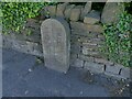
Borough boundary stone in Shelf
Image shows a closer look and a note on the history. Shelf UDC has been superseded by Calderdale Borough. Milestone Society National ID: YW_SHEL01pb
Image: © Stephen Craven
Taken: 10 Jul 2022
0.07 miles
7
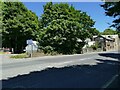
Borough boundary in Shelf
The 'Welcome to Bradford' sign is as near as makes no difference to the actual borough boundary. A change in the shade of the tarmac confirms that this is where respective highways authority agree the boundary.
Image: © Stephen Craven
Taken: 10 Jul 2022
0.07 miles
8
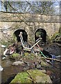
Riding Hill Bridge
Abandoned shopping trolley near the road bridge over Royds Hall Beck between Riding Hill and Manorley Lane. The beck forms part of the local authority boundary between Calderdale and Bradford.
Image: © Paul Glazzard
Taken: 1 Apr 2007
0.08 miles
9
Old milestone
On the A6036, Carr House Road, Buttershaw. This is one of 615 milestones erected for the West Riding County Council in 1893/94. Over half still remain by the roadside. The casting was made by Brayshaw & Booth of Liversedge and fixed to a large backing stone. This post, half way between Bradford and Halifax needs repainting.
Image: © Robert Glover
Taken: 17 Nov 2020
0.08 miles
10
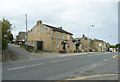
The New Furnace public house, Buttershaw
This is on Halifax Road. The street on the left is Beck Hill.
Image: © Humphrey Bolton
Taken: 6 Sep 2020
0.08 miles