IMAGES TAKEN NEAR TO
Folly Hall Road, BRADFORD, BD6 1UN
Introduction
This page details the photographs taken nearby to Folly Hall Road, BD6 1UN by members of the Geograph project.
The Geograph project started in 2005 with the aim of publishing, organising and preserving representative images for every square kilometre of Great Britain, Ireland and the Isle of Man.

There are currently over 7.5m images from over14,400 individuals and you can help contribute to the project by visiting https://www.geograph.org.uk
Image Map
Images are licensed for reuse under creativecommons.org/licenses/by-sa/2.0
Notes
- Clicking on the map will re-center to the selected point.
- The higher the marker number, the further away the image location is from the centre of the postcode.
Image Listing (110 Images Found)
Images are licensed for reuse under creativecommons.org/licenses/by-sa/2.0
Image
Details
Distance
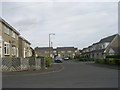
1
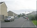
Folly Hall Avenue - Folly Hall Road
Image: © Betty Longbottom
Taken: 17 Oct 2011
0.02 miles
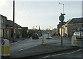
2
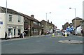
Wibsey High Street
High Street, the B6380, is straight on, and Folly hall Road, leading to Reevy Road, goes to the right at the little roundabout.
Image: © Humphrey Bolton
Taken: 19 Aug 2010
0.03 miles
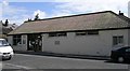
5
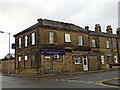
Wibsey Conservative Club, North Road/Reevy Road, Bradford
Image: © Stephen Armstrong
Taken: 3 Dec 2017
0.04 miles
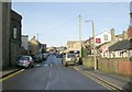
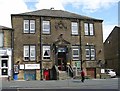
6
Folly Hall Close - Folly Hall Avenue
Image: © Betty Longbottom
Taken: 17 Oct 2011
0.05 miles
7
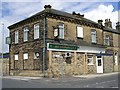
Wibsey Conservative Club - North Road
This was built in 1897.
Image: © Betty Longbottom
Taken: 18 Jul 2007
0.06 miles
9
Wesleyan Schools - School Lane
Built 1893.
Image: © Betty Longbottom
Taken: 18 Jul 2007
0.07 miles
10
Wibsey Liberal Club - Fair Road
Built 1883.
Image: © Betty Longbottom
Taken: 18 Jul 2007
0.08 miles