IMAGES TAKEN NEAR TO
Moulson Close, BRADFORD, BD6 1SQ
Introduction
This page details the photographs taken nearby to Moulson Close, BD6 1SQ by members of the Geograph project.
The Geograph project started in 2005 with the aim of publishing, organising and preserving representative images for every square kilometre of Great Britain, Ireland and the Isle of Man.

There are currently over 7.5m images from over14,400 individuals and you can help contribute to the project by visiting https://www.geograph.org.uk
Image Map (Loading...)


Getting Data...Please wait
Leaflet Map data © OpenStreetMap
Images are licensed for reuse under creativecommons.org/licenses/by-sa/2.0
Notes
- Clicking on the map will re-center to the selected point.
- The higher the marker number, the further away the image location is from the centre of the postcode.
Image Listing (96 Images Found)
Images are licensed for reuse under creativecommons.org/licenses/by-sa/2.0
Image
Details
Distance
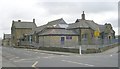
5
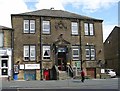
Wibsey Liberal Club - Fair Road
Built 1883.
Image: © Betty Longbottom
Taken: 18 Jul 2007
0.04 miles
9
Wibsey Primary School - Northfield Road
Image: © Betty Longbottom
Taken: 14 Mar 2009
0.06 miles
10

Moulson House, Fair Road, Wibsey
Dated 1880, and now a day nursery.
Image: © Humphrey Bolton
Taken: 19 Aug 2010
0.08 miles