IMAGES TAKEN NEAR TO
Odsal Road, BRADFORD, BD6 1PR
Introduction
This page details the photographs taken nearby to Odsal Road, BD6 1PR by members of the Geograph project.
The Geograph project started in 2005 with the aim of publishing, organising and preserving representative images for every square kilometre of Great Britain, Ireland and the Isle of Man.

There are currently over 7.5m images from over14,400 individuals and you can help contribute to the project by visiting https://www.geograph.org.uk
Image Map
Images are licensed for reuse under creativecommons.org/licenses/by-sa/2.0
Notes
- Clicking on the map will re-center to the selected point.
- The higher the marker number, the further away the image location is from the centre of the postcode.
Image Listing (103 Images Found)
Images are licensed for reuse under creativecommons.org/licenses/by-sa/2.0
Image
Details
Distance
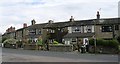
5
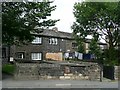
Croft, Wibsey
Cottages at an angle to Odsal Road.
Image: © Humphrey Bolton
Taken: 19 Aug 2010
0.04 miles
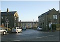
6
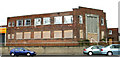
Odsal Police Station - Odsal Top
This is now disused.
Image: © Betty Longbottom
Taken: 11 Apr 2007
0.05 miles
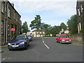
8
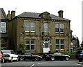
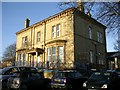
Pearson Road West
This property was built in 1881.
Image: © Betty Longbottom
Taken: 18 Jul 2007
0.05 miles
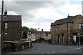
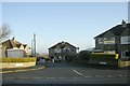
10
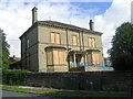
The former Odsal Clinic - viewed from Elmfield Drive
Image: © Betty Longbottom
Taken: 5 Aug 2011
0.06 miles