IMAGES TAKEN NEAR TO
Dukes Avenue, BRADFORD, BD6 1AY
Introduction
This page details the photographs taken nearby to Dukes Avenue, BD6 1AY by members of the Geograph project.
The Geograph project started in 2005 with the aim of publishing, organising and preserving representative images for every square kilometre of Great Britain, Ireland and the Isle of Man.

There are currently over 7.5m images from over14,400 individuals and you can help contribute to the project by visiting https://www.geograph.org.uk
Image Map
Images are licensed for reuse under creativecommons.org/licenses/by-sa/2.0
Notes
- Clicking on the map will re-center to the selected point.
- The higher the marker number, the further away the image location is from the centre of the postcode.
Image Listing (57 Images Found)
Images are licensed for reuse under creativecommons.org/licenses/by-sa/2.0
Image
Details
Distance
2
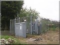
Electricity Substation No 701 - off Rooley Avenue
Image: © Betty Longbottom
Taken: 11 Apr 2011
0.06 miles
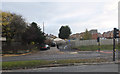
3
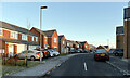
Northern View, Odsal, Bradford
Part of a relatively recent housing development adjacent to Odsal Stadium (now named the Provident Stadium), which is home to Bradford Bulls Rugby League Team (formerly Bradford Northern.)
Image: © Stephen Armstrong
Taken: 26 Oct 2021
0.06 miles
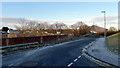
7
A cycle route leaving Rooley Avenue, Bradford
Image: © habiloid
Taken: 3 Nov 2019
0.08 miles
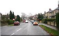
8
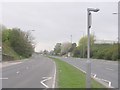
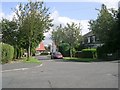
Rooley Avenue - viewed from Rooley Crescent
Image: © Betty Longbottom
Taken: 11 Apr 2011
0.09 miles
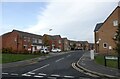
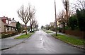
10
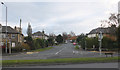
Rooley Crescent, Bradford
Rooley Avenue runs across the foreground.
Image: © habiloid
Taken: 3 Nov 2019
0.10 miles