IMAGES TAKEN NEAR TO
Farside Green, BRADFORD, BD5 9DF
Introduction
This page details the photographs taken nearby to Farside Green, BD5 9DF by members of the Geograph project.
The Geograph project started in 2005 with the aim of publishing, organising and preserving representative images for every square kilometre of Great Britain, Ireland and the Isle of Man.

There are currently over 7.5m images from over14,400 individuals and you can help contribute to the project by visiting https://www.geograph.org.uk
Image Map (151 Images)


Getting Data...Please wait
Leaflet Map data © OpenStreetMap
Images are licensed for reuse under creativecommons.org/licenses/by-sa/2.0
Notes
- Clicking on the map will re-center to the selected point.
- The higher the marker number, the further away the image location is from the centre of the postcode.
Image Listing (151 Images Found)
Images are licensed for reuse under creativecommons.org/licenses/by-sa/2.0
Image
Details
Distance
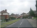
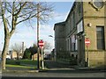
1
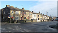
Little Horton Lane
Viewed from the corner with Thornton Lane, the junction with Farside Green is on the left.
Image: © habiloid
Taken: 8 Feb 2020
0.03 miles
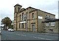
2
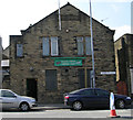
Chapel Green Liberal Club - Thornton Lane
Image: © Betty Longbottom
Taken: 7 Apr 2007
0.04 miles
3
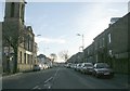
Thornton Lane - Little Horton Lane
Image: © Betty Longbottom
Taken: 22 Dec 2008
0.04 miles
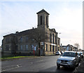
5
Shree Hindu Temple - Thornton Lane
Formerly a Chapel
Image: © Betty Longbottom
Taken: 7 Apr 2007
0.05 miles
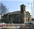
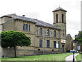
6
Shree Hindu Temple and Community Centre, Thornton Lane
Image: © habiloid
Taken: 8 Feb 2020
0.05 miles
8
Hindu temple in former chapel, Thornton Lane
Image: © Humphrey Bolton
Taken: 21 Oct 2011
0.05 miles
10
Bradford - Hindu Temple and Community Centre
Star Street Frontage. For an alternative view, please see Image
Image: © Dave Bevis
Taken: 29 Jun 2013
0.06 miles