IMAGES TAKEN NEAR TO
Carton Court, BRADFORD, BD5 8DE
Introduction
This page details the photographs taken nearby to Carton Court, BD5 8DE by members of the Geograph project.
The Geograph project started in 2005 with the aim of publishing, organising and preserving representative images for every square kilometre of Great Britain, Ireland and the Isle of Man.

There are currently over 7.5m images from over14,400 individuals and you can help contribute to the project by visiting https://www.geograph.org.uk
Image Map (Loading...)


Getting Data...Please wait
Leaflet Map data © OpenStreetMap
Images are licensed for reuse under creativecommons.org/licenses/by-sa/2.0
Notes
- Clicking on the map will re-center to the selected point.
- The higher the marker number, the further away the image location is from the centre of the postcode.
Image Listing (151 Images Found)
Images are licensed for reuse under creativecommons.org/licenses/by-sa/2.0
Image
Details
Distance
1
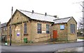
Park Methodist Church - Little Cross Street
Built 1878 as a United Methodist Free Church.
Image: © Betty Longbottom
Taken: 22 Dec 2007
0.04 miles
2
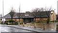
New Cross Street Health Centre
Now disused and boarded up!
Image: © Betty Longbottom
Taken: 22 Dec 2007
0.04 miles
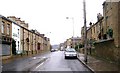
5
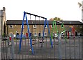
Playground - Ryan Street - Manchester Road
Image: © Betty Longbottom
Taken: 25 Oct 2008
0.06 miles
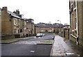
6
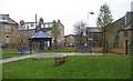
Jane Binns Memorial Park - Little Cross Street
Image: © Betty Longbottom
Taken: 22 Dec 2007
0.06 miles
9
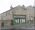
E Dunwell Newsagent - Parkside Road
Image: © Betty Longbottom
Taken: 11 Apr 2011
0.09 miles
10
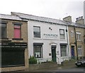
Parkside Dental Health Centre - Parkside Road
Image: © Betty Longbottom
Taken: 11 Apr 2011
0.09 miles