IMAGES TAKEN NEAR TO
Albany Street, BRADFORD, BD5 7JN
Introduction
This page details the photographs taken nearby to Albany Street, BD5 7JN by members of the Geograph project.
The Geograph project started in 2005 with the aim of publishing, organising and preserving representative images for every square kilometre of Great Britain, Ireland and the Isle of Man.

There are currently over 7.5m images from over14,400 individuals and you can help contribute to the project by visiting https://www.geograph.org.uk
Image Map
Images are licensed for reuse under creativecommons.org/licenses/by-sa/2.0
Notes
- Clicking on the map will re-center to the selected point.
- The higher the marker number, the further away the image location is from the centre of the postcode.
Image Listing (142 Images Found)
Images are licensed for reuse under creativecommons.org/licenses/by-sa/2.0
Image
Details
Distance
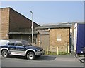
3
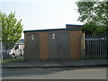
Electricity Substation No 1723 - Spring Mill Street
Image: © Betty Longbottom
Taken: 19 Apr 2011
0.03 miles
4
Spring Mill Street - Ripley Street
Image: © Betty Longbottom
Taken: 19 Apr 2011
0.04 miles
5
Bowling Mills and Bridge Tavern, Bowling Old Lane
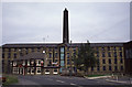
This mill is Bowling Mills one of a complex developed by Sir Henry Ripley from the mid-1860s. These included Spring Mill, Melange Mills, Springfield Mill and Bowling Mills. Review of Betty's picture of the pub http://www.geograph.org.uk/photo/397408 and the satellite image suggests that this has gone and been replaced by a modern industrial estate.
Thanks to Harry Burnell for identifying the mill and stating the owner as Bowling mills Combing Company.
Image: © Chris Allen
Taken: 21 Jul 1990
0.04 miles
7
Electricity Substation No 574 - Spring Mill Street
Image: © Betty Longbottom
Taken: 19 Apr 2011
0.05 miles
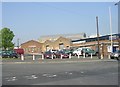
8
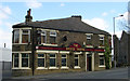
The Bridge Tavern - Bowling Old Lane
Image: © Betty Longbottom
Taken: 11 Apr 2007
0.06 miles
9
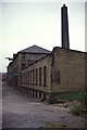
Bowling Mills, West Bowling, Bradford
The chimney is seen in another of my photographs. These were taken on a trip to Jesse Street Dyeworks and I suspect this mill is no more. I would welcome any more information.
Harry Burnell writes:
This is Bowling Mills in Gower Street. Bowling Mills was bounded by Manchester Road, Bowling Old Lane, Albany Street and Gower Street.
The pic was taken at the Manchester Road end of Gower Street, looking towards its junction with Albany Street.
This is the wool combing part of Bowling Mills Combing. Just inside the Gower Street gate was the chimney and boiler house.
Image: © Chris Allen
Taken: 21 Jul 1990
0.06 miles
10
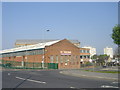
El-Shaddai Christian Centre - Bowling Old Lane
Image: © Betty Longbottom
Taken: 19 Apr 2011
0.06 miles