IMAGES TAKEN NEAR TO
Baird Street, BRADFORD, BD5 7EP
Introduction
This page details the photographs taken nearby to Baird Street, BD5 7EP by members of the Geograph project.
The Geograph project started in 2005 with the aim of publishing, organising and preserving representative images for every square kilometre of Great Britain, Ireland and the Isle of Man.

There are currently over 7.5m images from over14,400 individuals and you can help contribute to the project by visiting https://www.geograph.org.uk
Image Map
Images are licensed for reuse under creativecommons.org/licenses/by-sa/2.0
Notes
- Clicking on the map will re-center to the selected point.
- The higher the marker number, the further away the image location is from the centre of the postcode.
Image Listing (111 Images Found)
Images are licensed for reuse under creativecommons.org/licenses/by-sa/2.0
Image
Details
Distance
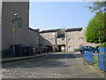
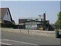
2
Electricity Substation No 464 - Vere Square
Image: © Betty Longbottom
Taken: 19 Apr 2011
0.05 miles
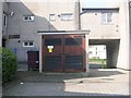
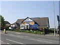
5
The Newby Square - Bowling Old Lane
Image: © Betty Longbottom
Taken: 19 Apr 2011
0.06 miles
6
Light of the World Gospel Hall & Community Church - Bowling Old Lane
Image: © Betty Longbottom
Taken: 19 Apr 2011
0.06 miles
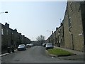
7
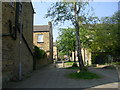
Bowbridge Street - Spring Mill Street
Image: © Betty Longbottom
Taken: 19 Apr 2011
0.06 miles
8
Pembroke Street - St Stephen's Road
Image: © Betty Longbottom
Taken: 19 Apr 2011
0.07 miles
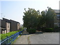
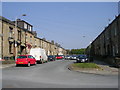
10
Gaythorne Road - viewed from St Stephen's Road
Image: © Betty Longbottom
Taken: 19 Apr 2011
0.07 miles