IMAGES TAKEN NEAR TO
Knowles Lane, BRADFORD, BD4 9AA
Introduction
This page details the photographs taken nearby to Knowles Lane, BD4 9AA by members of the Geograph project.
The Geograph project started in 2005 with the aim of publishing, organising and preserving representative images for every square kilometre of Great Britain, Ireland and the Isle of Man.

There are currently over 7.5m images from over14,400 individuals and you can help contribute to the project by visiting https://www.geograph.org.uk
Image Map
Images are licensed for reuse under creativecommons.org/licenses/by-sa/2.0
Notes
- Clicking on the map will re-center to the selected point.
- The higher the marker number, the further away the image location is from the centre of the postcode.
Image Listing (85 Images Found)
Images are licensed for reuse under creativecommons.org/licenses/by-sa/2.0
Image
Details
Distance
1
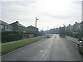
St Margaret's Avenue - Knowles Lane
Image: © Betty Longbottom
Taken: 1 Mar 2011
0.02 miles
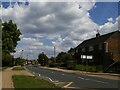
2
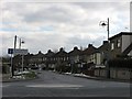
St Margaret's Avenue
Viewed from Knowles Lane. The "No Through Road" sign is to stop people using it as a rat-run, to avoid the frequently unbearable traffic on Tong Street.
Image: © Stephen Armstrong
Taken: 1 Apr 2013
0.02 miles
3
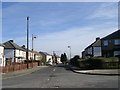
Knowles Avenue - St Margaret's Avenue
Image: © Betty Longbottom
Taken: 1 Mar 2011
0.04 miles
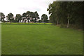
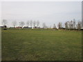
7
Footpath across Knowles Park - Knowles Lane
Image: © Betty Longbottom
Taken: 1 Mar 2011
0.07 miles
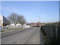
9
Knowles Lane outside Knowleswood Primary School
With a zebra crossing.
Image: © Stephen Craven
Taken: 5 Jun 2021
0.09 miles
10
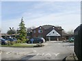
Knowles Court Nursing Home - Bridgeway
Image: © Betty Longbottom
Taken: 1 Mar 2011
0.09 miles