IMAGES TAKEN NEAR TO
Bowling Back Lane, BRADFORD, BD4 8TG
Introduction
This page details the photographs taken nearby to Bowling Back Lane, BD4 8TG by members of the Geograph project.
The Geograph project started in 2005 with the aim of publishing, organising and preserving representative images for every square kilometre of Great Britain, Ireland and the Isle of Man.

There are currently over 7.5m images from over14,400 individuals and you can help contribute to the project by visiting https://www.geograph.org.uk
Image Map
Images are licensed for reuse under creativecommons.org/licenses/by-sa/2.0
Notes
- Clicking on the map will re-center to the selected point.
- The higher the marker number, the further away the image location is from the centre of the postcode.
Image Listing (117 Images Found)
Images are licensed for reuse under creativecommons.org/licenses/by-sa/2.0
Image
Details
Distance
1
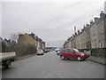
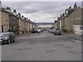
Buller Street - looking towards Sticker Lane
Image: © Betty Longbottom
Taken: 9 Feb 2011
0.03 miles
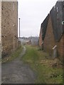
3
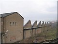
Swain Green Mills - viewed from Buller Street
Image: © Betty Longbottom
Taken: 9 Feb 2011
0.03 miles
4
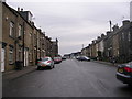
Alma Street - looking towards Sticker Lane
Image: © Betty Longbottom
Taken: 9 Feb 2011
0.04 miles
5
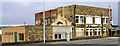
Laisterdyke Working Men's Club - Sticker Lane
Image: © Betty Longbottom
Taken: 31 Mar 2007
0.08 miles
6
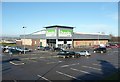
Dunelm Mill shop, Sticker Lane, Bowling
On the ring road, with a large car park.
Image: © Humphrey Bolton
Taken: 3 Feb 2011
0.08 miles
7
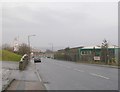
Bowling Back Lane - viewed from near Planetrees Road
Image: © Betty Longbottom
Taken: 9 Feb 2011
0.09 miles
10

The Swain Green
Public house on Sticker Lane
Image: © Chris Heaton
Taken: 26 Jul 2016
0.11 miles