IMAGES TAKEN NEAR TO
Corban Street, BRADFORD, BD4 8RH
Introduction
This page details the photographs taken nearby to Corban Street, BD4 8RH by members of the Geograph project.
The Geograph project started in 2005 with the aim of publishing, organising and preserving representative images for every square kilometre of Great Britain, Ireland and the Isle of Man.

There are currently over 7.5m images from over14,400 individuals and you can help contribute to the project by visiting https://www.geograph.org.uk
Image Map
Images are licensed for reuse under creativecommons.org/licenses/by-sa/2.0
Notes
- Clicking on the map will re-center to the selected point.
- The higher the marker number, the further away the image location is from the centre of the postcode.
Image Listing (93 Images Found)
Images are licensed for reuse under creativecommons.org/licenses/by-sa/2.0
Image
Details
Distance
1
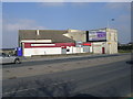
Dudley Hill & Tong Socialist Club - Sticker Lane
Image: © Betty Longbottom
Taken: 8 Mar 2011
0.01 miles
2
Dudley Hill & Tong Socialist Club - Sticker Lane
Image: © Betty Longbottom
Taken: 31 Mar 2007
0.02 miles


6
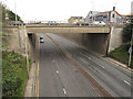
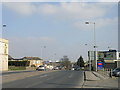
Dudley Hill interchange
The A650 Wakefield Road is in a cutting at this point, reached by slip roads from the roundabout on the Bradford Ring Road above. This is quiet traffic on Saturday morning; it would be different on a weekday rush hour. Photographed from the pedestrian bridge Image
Image: © Stephen Craven
Taken: 10 Sep 2016
0.06 miles
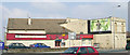
8
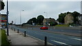
Wakefield Road near Dudley Hill, Bradford
Looking south towards Dudley Hill roundabout on the Bradford Outer Ring Road, which passes over Wakefield Road, which then becomes Tong Street at the other side of the underpass.
Image: © Stephen Armstrong
Taken: 21 Jul 2021
0.07 miles
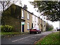
9
Former children's playground off Longfield Drive
Image: © Glyn Drury
Taken: 30 Jun 2009
0.07 miles