IMAGES TAKEN NEAR TO
Dence Green, BRADFORD, BD4 8LR
Introduction
This page details the photographs taken nearby to Dence Green, BD4 8LR by members of the Geograph project.
The Geograph project started in 2005 with the aim of publishing, organising and preserving representative images for every square kilometre of Great Britain, Ireland and the Isle of Man.

There are currently over 7.5m images from over14,400 individuals and you can help contribute to the project by visiting https://www.geograph.org.uk
Image Map
Images are licensed for reuse under creativecommons.org/licenses/by-sa/2.0
Notes
- Clicking on the map will re-center to the selected point.
- The higher the marker number, the further away the image location is from the centre of the postcode.
Image Listing (68 Images Found)
Images are licensed for reuse under creativecommons.org/licenses/by-sa/2.0
Image
Details
Distance
2
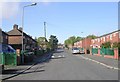
Dudley Street - looking towards Dick Lane
Image: © Betty Longbottom
Taken: 16 Nov 2010
0.04 miles
4
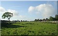
View from Bridge 29 over Tunnel - Sutton Road, Sutton Estate - looking towards Tyersal Lane
Disused Railway.
Image: © Betty Longbottom
Taken: 9 Oct 2008
0.06 miles
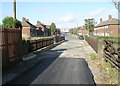
5

Gates at the end of Dudley Street, Laisterdyke
Laisterdyke once boasted the Great Northern's railway station with four platforms and a complicated double-triangular junction with lines radiating to Bradford, Shipley, Leeds (by two routes), Wakefield, Dewsbury and Halifax. The station closed in 1966, most of the lines around the same time, and only the through route from Bradford to Leeds now remains, with no station. Just beyond these gates there was once a bridge crossing one of the curves of the southern triangle. The cutting has been filled in and the bridge removed.
Image: © Stephen Craven
Taken: 5 Sep 2020
0.06 miles
6
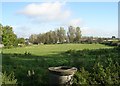
View from Bridge 29 over Tunnel - Sutton Road, Sutton Estate
Disused Railway.
Image: © Betty Longbottom
Taken: 9 Oct 2008
0.07 miles
7
Bridge 29 over Tunnel - Sutton Road, Sutton Estate
Disused Railway.
Image: © Betty Longbottom
Taken: 9 Oct 2008
0.07 miles
8

Former railway bridge on Sutton Road, Laisterdyke
Laisterdyke once boasted the Great Northern's railway station with four platforms and a complicated double-triangular junction with lines radiating to Bradford, Shipley, Leeds (by two routes), Wakefield, Dewsbury and Halifax. The station closed in 1966, most of the lines around the same time, and only the through route from Bradford to Leeds now remains, with no station. This bridge once crossed one of the curves of the southern triangle. The cutting has been filled in.
Image: © Stephen Craven
Taken: 5 Sep 2020
0.08 miles