IMAGES TAKEN NEAR TO
Arkwright Street, BRADFORD, BD4 8JL
Introduction
This page details the photographs taken nearby to Arkwright Street, BD4 8JL by members of the Geograph project.
The Geograph project started in 2005 with the aim of publishing, organising and preserving representative images for every square kilometre of Great Britain, Ireland and the Isle of Man.

There are currently over 7.5m images from over14,400 individuals and you can help contribute to the project by visiting https://www.geograph.org.uk
Image Map
Images are licensed for reuse under creativecommons.org/licenses/by-sa/2.0
Notes
- Clicking on the map will re-center to the selected point.
- The higher the marker number, the further away the image location is from the centre of the postcode.
Image Listing (78 Images Found)
Images are licensed for reuse under creativecommons.org/licenses/by-sa/2.0
Image
Details
Distance
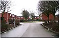
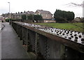
2
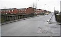
Arkwright Street, Tyersal
Showing the former railway bridge over the closed Laisterdyke to Dudley Hill branch line which was in a, now filled in, cutting at this point.
Image: © Steve Partridge
Taken: 9 Oct 2007
0.02 miles
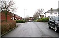
3
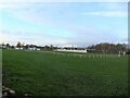
Tyersal FC Football Pitch, Arkwright Street, Bradford
Image: © Stephen Armstrong
Taken: 24 Nov 2021
0.05 miles
4
Disused Railway Bridge, Arkwright Street
There is a cut bench mark on the bridge parapet to the right of the photograph and a closer view can be seen here: Image
Image: © Mark Anderson
Taken: 13 Jan 2017
0.05 miles
5
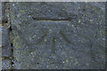
Cut Bench Mark, Arkwright Street Railway Bridge
Bench Mark Database: http://www.bench-marks.org.uk/bm81413
Image: © Mark Anderson
Taken: 13 Jan 2017
0.05 miles
6
Former Railway Bridge, Arkwright Street, Bradford
See Stephen Craven's image Image for a comprehensive description.
Image: © Stephen Armstrong
Taken: 24 Nov 2021
0.05 miles
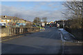
7
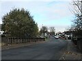
Road Bridge over Disused Railway - Tyersal Road
Image: © Betty Longbottom
Taken: 23 Jan 2008
0.06 miles
9
Railway bridge, Tyersal
A parapet of the disused bridge shown at http://www.geograph.org.uk/gridref/SE1932?centi=SE193326 .
Image: © Derek Harper
Taken: 21 Dec 2012
0.06 miles
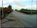
10

Arkwright Street railway bridge, Laisterdyke
Laisterdyke once boasted the Great Northern's railway station with four platforms and a complicated double-triangular junction with lines radiating to Bradford, Shipley, Leeds (by two routes), Wakefield, Dewsbury and Halifax. The station closed in 1966, most of the lines around the same time, and only the through route from Bradford to Leeds now remains, with no station. This bridge crossed four tracks of Cutlers Junction at the southern end of the northern triangle.
Image: © Stephen Craven
Taken: 5 Sep 2020
0.06 miles