IMAGES TAKEN NEAR TO
Laisterdyke, BRADFORD, BD4 8AR
Introduction
This page details the photographs taken nearby to Laisterdyke, BD4 8AR by members of the Geograph project.
The Geograph project started in 2005 with the aim of publishing, organising and preserving representative images for every square kilometre of Great Britain, Ireland and the Isle of Man.

There are currently over 7.5m images from over14,400 individuals and you can help contribute to the project by visiting https://www.geograph.org.uk
Image Map
Images are licensed for reuse under creativecommons.org/licenses/by-sa/2.0
Notes
- Clicking on the map will re-center to the selected point.
- The higher the marker number, the further away the image location is from the centre of the postcode.
Image Listing (262 Images Found)
Images are licensed for reuse under creativecommons.org/licenses/by-sa/2.0
Image
Details
Distance
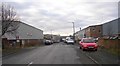
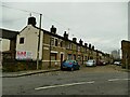
1
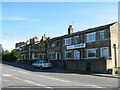
Cottages, Laisterdyke, Bradford
Laisterdyke is part of the Bradford Ring Road, so it is normally very busy. However this was 9.20 Sunday morning, hence the lack of traffic.
Image: © Stephen Armstrong
Taken: 11 Jun 2017
0.01 miles
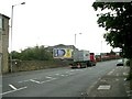
3
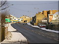
Laisterdyke, Bradford
Looking towards Leeds Road traffic lights from the bridge over the railway. Through the traffic lights is Killinghall Road.
Image: © Stephen Armstrong
Taken: 3 Jan 2010
0.03 miles

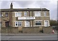
6
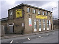
United Plastic & Glass - Laisterdyke
Image: © Betty Longbottom
Taken: 14 Feb 2010
0.04 miles
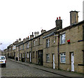
10
Mortimer Row, off Bradford Lane
Most of the terraced housing in this part of Bradford has been demolished to make way for other uses, but this terrace of stone houses fronting a stone-setted street and dating from c.1830 benefits from Grade II listing status (entry 1314512).
Image: © Stephen Craven
Taken: 30 Jan 2021
0.06 miles