IMAGES TAKEN NEAR TO
Rooley Lane, BRADFORD, BD4 7SQ
Introduction
This page details the photographs taken nearby to Rooley Lane, BD4 7SQ by members of the Geograph project.
The Geograph project started in 2005 with the aim of publishing, organising and preserving representative images for every square kilometre of Great Britain, Ireland and the Isle of Man.

There are currently over 7.5m images from over14,400 individuals and you can help contribute to the project by visiting https://www.geograph.org.uk
Image Map
Images are licensed for reuse under creativecommons.org/licenses/by-sa/2.0
Notes
- Clicking on the map will re-center to the selected point.
- The higher the marker number, the further away the image location is from the centre of the postcode.
Image Listing (118 Images Found)
Images are licensed for reuse under creativecommons.org/licenses/by-sa/2.0
Image
Details
Distance
1
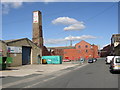
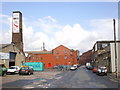
Old mill chimney, Factory Street, Bowling (Bradford)
Still useful for advertisements.
Image: © Humphrey Bolton
Taken: 10 Sep 2007
0.02 miles
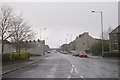
5
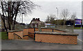
Pedestrian underpass, Rooley Lane (A6177), Bradford
This underpass is at the junction of Rooley Lane and Bowling Hall Road.
Image: © habiloid
Taken: 14 Feb 2021
0.05 miles