IMAGES TAKEN NEAR TO
Wakefield Road, BRADFORD, BD4 7PR
Introduction
This page details the photographs taken nearby to Wakefield Road, BD4 7PR by members of the Geograph project.
The Geograph project started in 2005 with the aim of publishing, organising and preserving representative images for every square kilometre of Great Britain, Ireland and the Isle of Man.

There are currently over 7.5m images from over14,400 individuals and you can help contribute to the project by visiting https://www.geograph.org.uk
Image Map
Images are licensed for reuse under creativecommons.org/licenses/by-sa/2.0
Notes
- Clicking on the map will re-center to the selected point.
- The higher the marker number, the further away the image location is from the centre of the postcode.
Image Listing (105 Images Found)
Images are licensed for reuse under creativecommons.org/licenses/by-sa/2.0
Image
Details
Distance
1
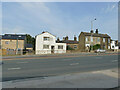
Houses on Wakefield Road, Bradford
These clearly pre-date the widening of the road to a dual carriageway.
Image: © Stephen Craven
Taken: 10 Aug 2020
0.01 miles
2
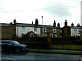
10 and 12 Billingsley Terrace, Bradford
Early C19 Grade II Listed houses, probably built circa 1820. Note how the original doorway and fanlight have been incorporated into the small porch on the left hand house (No.12). https://historicengland.org.uk/listing/the-list/list-entry/1133277
Image: © Stephen Armstrong
Taken: 12 Jan 2023
0.02 miles

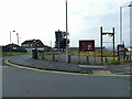
4
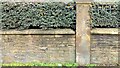
OS Cut Benchmark, Wakefield Road, Bradford
On the boundary wall of the former Lorne Street Primary School. The site is now the pdsa Pet Hospital.
Image: © Stephen Armstrong
Taken: 12 Jan 2023
0.03 miles
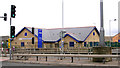
5
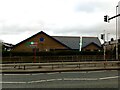
pdsa Pet Hospital, Lorne Street / Wakefield Road, Bradford
The Jeanne Marchig Centre, built on the site of the former Lorne Street Primary School which closed in 2000. Seen across Wakefield Road from the end of Lister Avenue.
Image: © Stephen Armstrong
Taken: 12 Jan 2023
0.03 miles
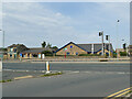
7
Galloped away, Wakefield Road, Bradford
There used to be a pub called the Gallopers here. We don't appear to have a photo of it on here, but it appears on the April 2019 Google Streetview so it must only have been demolished in the last year or so. It was a modern building, although the 1908 map shows an earlier pub on the site.
Image: © Stephen Craven
Taken: 10 Aug 2020
0.04 miles

10
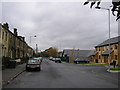
Lorne Street, Bradford
Looking towards Wakefield Road
Image: © Stephen Armstrong
Taken: 7 Dec 2009
0.05 miles