IMAGES TAKEN NEAR TO
Flockton Terrace, BRADFORD, BD4 7LF
Introduction
This page details the photographs taken nearby to Flockton Terrace, BD4 7LF by members of the Geograph project.
The Geograph project started in 2005 with the aim of publishing, organising and preserving representative images for every square kilometre of Great Britain, Ireland and the Isle of Man.

There are currently over 7.5m images from over14,400 individuals and you can help contribute to the project by visiting https://www.geograph.org.uk
Image Map
Images are licensed for reuse under creativecommons.org/licenses/by-sa/2.0
Notes
- Clicking on the map will re-center to the selected point.
- The higher the marker number, the further away the image location is from the centre of the postcode.
Image Listing (121 Images Found)
Images are licensed for reuse under creativecommons.org/licenses/by-sa/2.0
Image
Details
Distance

4
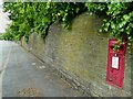
Postbox on Bowling Hall Road
Set into the wall.
Image: © Stephen Craven
Taken: 6 Jun 2021
0.04 miles
5

New Hey Road - viewed from Flockton Road
Image: © Betty Longbottom
Taken: 28 Feb 2011
0.05 miles
6
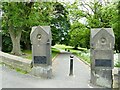
Bowling Park: north entrance
At the junction of Bowling Park Drive and Bowling Hall Road.
Image: © Stephen Craven
Taken: 6 Jun 2021
0.06 miles
7
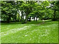
Bowling Park: path behind the West Lodge
The upper part of this path is surfaced but towards the lodge the macadam stops.
Image: © Stephen Craven
Taken: 6 Jun 2021
0.07 miles
8
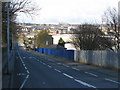
Bowling Park Drive, Bradford
From the junction with Bowling Hall Road.
Image: © Stephen Armstrong
Taken: 4 Apr 2010
0.07 miles
9

Flockton Drive - Bowling Hall Road
Image: © Betty Longbottom
Taken: 28 Feb 2011
0.07 miles