IMAGES TAKEN NEAR TO
St. Dunstans Way, BRADFORD, BD4 7EG
Introduction
This page details the photographs taken nearby to St. Dunstans Way, BD4 7EG by members of the Geograph project.
The Geograph project started in 2005 with the aim of publishing, organising and preserving representative images for every square kilometre of Great Britain, Ireland and the Isle of Man.

There are currently over 7.5m images from over14,400 individuals and you can help contribute to the project by visiting https://www.geograph.org.uk
Image Map
Images are licensed for reuse under creativecommons.org/licenses/by-sa/2.0
Notes
- Clicking on the map will re-center to the selected point.
- The higher the marker number, the further away the image location is from the centre of the postcode.
Image Listing (151 Images Found)
Images are licensed for reuse under creativecommons.org/licenses/by-sa/2.0
Image
Details
Distance
1
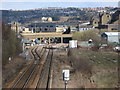
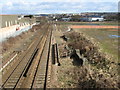
St. Dunstans railway station (site), Bradford, Yorkshire
Opened in 1878 jointly by the Lancashire & Yorkshire Railway and the Great Northern Railway, principally for interchange purposes, this station closed in 1952.
View north towards Bradford. The L&Y Halifax to Bradford lines curved in from bottom left of the image with the platforms under and to the right of the modern building. The GN platforms on the Leeds-Bradford line are out of view in the distance. That railway line is still extant but no trace of the station appears to remain.
For more information, see http://www.disused-stations.org.uk/s/st.dunstan%27s/index.shtml.
Image: © Nigel Thompson
Taken: 9 Jul 2022
0.04 miles
2
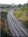
Dunstan Curve Bradford
The partly re-laid Dunstan Curve on the approach to Bradford Interchange Station looking toward Mill Lane Junction. Done as part of the re-modelling of the junction. Viewed from bridge LBE4/5,Bolling Road. If anybody's interested the Loco is 66145.
Image: © Stephen Armstrong
Taken: 26 Oct 2008
0.04 miles
3
St. Dunstans railway station (site), Bradford, Yorkshire
Opened in 1878 jointly by the Lancashire & Yorkshire Railway and the Great Northern Railway, principally for interchange purposes, this station closed in 1952.
View north west towards Bradford. The GN platforms on the Leeds-Bradford line have been demolished. The L&Y Halifax to Bradford lines were in front of the modern building to the left - all trace of those platforms has also been removed, along with the track.
For more information, see http://www.disused-stations.org.uk/s/st.dunstan%27s/index.shtml.
Image: © Nigel Thompson
Taken: 9 Jul 2022
0.04 miles
4
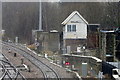
Mill Lane Junction Signal Box
Long distance view from the bridge on Caledonia Street in the rain.
See Image] for context.
Image: © JThomas
Taken: 14 Feb 2020
0.07 miles
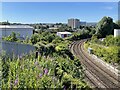
5
Mill Lane Junction & Caledonia Street Bridge, Bradford
The approach to Bradford Interchange, viewed with plenty of zoom from Ripley Street Bridge. You can just see the platforms of The Interchange through the bridge.
Image: © Stephen Armstrong
Taken: 1 Apr 2010
0.08 miles
6
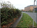
Brambles on Bolling Road, Bradford
Brambles growing over the pavement - not good for partially sighted pedestrians like me.
Image: © Stephen Armstrong
Taken: 6 Nov 2022
0.09 miles
7
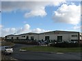
Kings Security Systems, Ripley Street, Bradford
Image: © Stephen Armstrong
Taken: 1 Apr 2010
0.09 miles
8
Mill Lane coal drops, Bradford
The railway viaduct led to a coal yard serving and adjacent gas works (all now gone), but this coal drop or staithe was to enable local coal merchants to collect their wares.
Image: © Stephen Craven
Taken: 6 Jun 2021
0.10 miles
9
View north from Bridge MRB/57, Ripley Street, Bradford
The Bradford Interchange to Halifax line looking towards Bradford.
Image: © Stephen Armstrong
Taken: 1 Apr 2010
0.10 miles
10
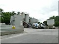
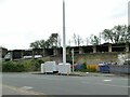
Wincanton Concrete, Mill Lane, Bradford
Image: © Stephen Craven
Taken: 6 Jun 2021
0.10 miles