IMAGES TAKEN NEAR TO
Watercock Street, BRADFORD, BD4 7DZ
Introduction
This page details the photographs taken nearby to Watercock Street, BD4 7DZ by members of the Geograph project.
The Geograph project started in 2005 with the aim of publishing, organising and preserving representative images for every square kilometre of Great Britain, Ireland and the Isle of Man.

There are currently over 7.5m images from over14,400 individuals and you can help contribute to the project by visiting https://www.geograph.org.uk
Image Map
Images are licensed for reuse under creativecommons.org/licenses/by-sa/2.0
Notes
- Clicking on the map will re-center to the selected point.
- The higher the marker number, the further away the image location is from the centre of the postcode.
Image Listing (126 Images Found)
Images are licensed for reuse under creativecommons.org/licenses/by-sa/2.0
Image
Details
Distance
1
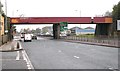
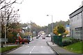
Railway Bridge - Wakefield Road - looking towards Bradford
This bridge carries a now dismantled railway over the road.
Image: © Betty Longbottom
Taken: 4 Nov 2008
0.01 miles
2
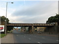
Disused Railway Bridge BRB DUH47, Wakefield Road
Until recently the sides of the deck were covered with red corrugated panels which made it look quite pleasant.....now it just looks scruffy. It was on the former GNR Line from Laisterdyke to Bowling Junction (The Bradford Avoiding Line).
Image: © Stephen Armstrong
Taken: 11 Jun 2017
0.03 miles
3
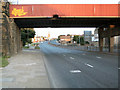
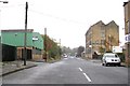
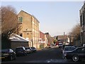
Wakefield Road
Seen from just NW of the disused railway bridge, looking SE up the hill towards Bowling and Dudley Hill. The church in the distance is St John's, Bowling. The railway was once Bradford's avoiding line (running from Laisterdyke to Bowling Junction and Low Moor) but closed many years ago.
Image: © David Spencer
Taken: 8 Aug 2005
0.04 miles
8
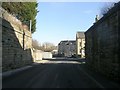
Bridge BRPB - DUH 46A - Square Street
This railway bridge has long since been demolished.
Image: © Betty Longbottom
Taken: 8 Feb 2011
0.07 miles
10
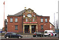
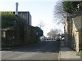
Guru Nanak Sikh Temple - Wakefield Road
Formerly Prospect Hall, built 1912
Image: © Betty Longbottom
Taken: 3 Apr 2007
0.09 miles