IMAGES TAKEN NEAR TO
Barnard Road, BRADFORD, BD4 7DX
Introduction
This page details the photographs taken nearby to Barnard Road, BD4 7DX by members of the Geograph project.
The Geograph project started in 2005 with the aim of publishing, organising and preserving representative images for every square kilometre of Great Britain, Ireland and the Isle of Man.

There are currently over 7.5m images from over14,400 individuals and you can help contribute to the project by visiting https://www.geograph.org.uk
Image Map
Images are licensed for reuse under creativecommons.org/licenses/by-sa/2.0
Notes
- Clicking on the map will re-center to the selected point.
- The higher the marker number, the further away the image location is from the centre of the postcode.
Image Listing (145 Images Found)
Images are licensed for reuse under creativecommons.org/licenses/by-sa/2.0
Image
Details
Distance

2
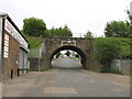
Disused Railway Bridge BRB DUH48, Barnard Road
This was on the former GNR Line from Laisterdyke to Bowling Junction (The Bradford Avoiding Line). The height restriction of 14'9" looks rather optimistic to me. There is an OS Cut Benchmark low down on the left hand wall just before the arch. Image
Image: © Stephen Armstrong
Taken: 13 Jun 2010
0.03 miles
3
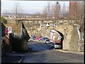
Bridge 4S - Barnard Road
This bridge carried a now dismantled railway over Barnard Road.
Image: © Betty Longbottom
Taken: 8 Feb 2011
0.04 miles
4
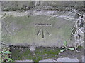
OS Cut Benchmark, Barnard Road
Cut Benchmark on the retaining wall just NW of the disused Railway Bridge BRB DUH48. Image Details at http://www.bench-marks.org.uk/bm86612
Image: © Stephen Armstrong
Taken: 20 Sep 2015
0.04 miles
5

OS Cut Benchmark, 18 Usher Street
This is on the boundary wall immediately right of a pair of metal gates. Details at https://www.bench-marks.org.uk/bm86613. The building has been vacant for several years and is now badly vandalized.
Image: © Stephen Armstrong
Taken: 30 Sep 2018
0.04 miles
6

Impressive building on Usher Street
This attractive but dishevelled old building on Usher Street is not getting the care it deserves. The stone panel on the gable to right of the picture gives the date 1902 and also bears traces of painted letters. Although they are impossible to read now, they look as if they might have said 'Police Station' at one time.
It is now in residential use.
Image: © Antony Dixon
Taken: 2 Aug 2013
0.04 miles
7

Almost Derelict Building, Usher Street
Possibly a former Police Station, this building has been vacant for several years and the condition is rapidly deteriorating. See Image The single storey building at the far end is in considerably better condition and may still be in use. There is an OS Cut Benchmark Image at this end of the roadside wall, next to the gate.
Image: © Stephen Armstrong
Taken: 30 Sep 2018
0.05 miles
8

Disused Building, Usher Street
Possibly a former Police Station. It is in considerably better condition here than in my photo taken on 30th September 2018. Image
Image: © Stephen Armstrong
Taken: 20 Sep 2015
0.05 miles
9

OS Cut Benchmark, Usher Street Railway Bridge LBE4/3
This is on the north parapet, at the eastern end.
Image: © Stephen Armstrong
Taken: 14 May 2017
0.05 miles
10

Usher Street Railway Bridge LBE4/3
There is an OS Cut Benchmark on the large stone at the base of the right hand parapet at this end. See Image
Image: © Stephen Armstrong
Taken: 14 May 2017
0.05 miles