IMAGES TAKEN NEAR TO
Winfield Drive, BRADFORD, BD4 6RJ
Introduction
This page details the photographs taken nearby to Winfield Drive, BD4 6RJ by members of the Geograph project.
The Geograph project started in 2005 with the aim of publishing, organising and preserving representative images for every square kilometre of Great Britain, Ireland and the Isle of Man.

There are currently over 7.5m images from over14,400 individuals and you can help contribute to the project by visiting https://www.geograph.org.uk
Image Map
Images are licensed for reuse under creativecommons.org/licenses/by-sa/2.0
Notes
- Clicking on the map will re-center to the selected point.
- The higher the marker number, the further away the image location is from the centre of the postcode.
Image Listing (23 Images Found)
Images are licensed for reuse under creativecommons.org/licenses/by-sa/2.0
Image
Details
Distance
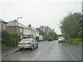
3
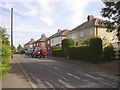
Winfield Drive, East Bierley, Hunsworth
This short cul-de-sac of semi-detached houses is part of ribbon development that took place along Hunsworth Lane before 1940, probably in the 1930s.
Image: © Humphrey Bolton
Taken: 23 Aug 2007
0.07 miles
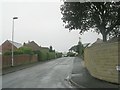
4
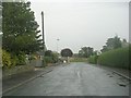
Ladyroyd Drive - looking towards Hunsworth Lane
Image: © Betty Longbottom
Taken: 20 Sep 2011
0.08 miles

7
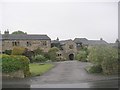
Upper Park House Farm - Hunsworth Lane
Image: © Betty Longbottom
Taken: 20 Sep 2011
0.13 miles