IMAGES TAKEN NEAR TO
New Toftshaw, BRADFORD, BD4 6QN
Introduction
This page details the photographs taken nearby to New Toftshaw, BD4 6QN by members of the Geograph project.
The Geograph project started in 2005 with the aim of publishing, organising and preserving representative images for every square kilometre of Great Britain, Ireland and the Isle of Man.

There are currently over 7.5m images from over14,400 individuals and you can help contribute to the project by visiting https://www.geograph.org.uk
Image Map
Images are licensed for reuse under creativecommons.org/licenses/by-sa/2.0
Notes
- Clicking on the map will re-center to the selected point.
- The higher the marker number, the further away the image location is from the centre of the postcode.
Image Listing (42 Images Found)
Images are licensed for reuse under creativecommons.org/licenses/by-sa/2.0
Image
Details
Distance
1
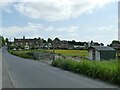
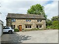
New Toftshaw
There must be some interesting history to a pair of rows of cottages built at right angles to the road, with nothing either side for several hundred metres. But I've not found anything online to explain it.
Image: © Stephen Craven
Taken: 4 Jun 2023
0.00 miles
2
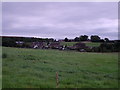
New Toftshaw BD4
View from SE185299 on Shetcliffe Lane, looking SE towards New Toftshaw, (the terraced houses).
Image: © Stephen Armstrong
Taken: 11 Sep 2005
0.01 miles
5
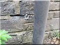
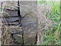
Ordnance Survey Cut Mark
This mark can be found on the roadside wall of a house at New Toftshaw. The benchmark height is recorded as being 182.133 metres above sea level.
For more detail see : https://www.bench-marks.org.uk/bm124488
Image: © Peter Wood
Taken: 9 Jun 2020
0.04 miles
6
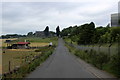
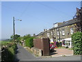
Toftshaw New Road
Heading for Shetcliffe Lane, Tong Street
Image: © Chris Heaton
Taken: 17 Jun 2018
0.05 miles
7
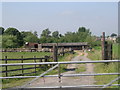
Track to Stables - Toftshaw New Road
Image: © Betty Longbottom
Taken: 27 Jun 2011
0.05 miles
8
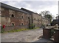
Model Farm, Toftshaw Lane, Hunsworth
The name suggests that the farm was built (or rebuilt), probably in the late 19C, in accordance with the latest ideas, probably with much mechanisation.
Image: © Humphrey Bolton
Taken: 27 Aug 2007
0.09 miles
9
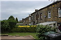
Toftshaw
This is probably the oldest house in the immediate area, lending its name to the later New Toftshaw Image It is not listed though, perhaps because of the extent of modernisation. Photographed from the public footpath that passes it.
Image: © Stephen Craven
Taken: 4 Jun 2023
0.10 miles
10
Ordnance Survey Cut Mark
This mark can be found on a stone post beside Toftshaw New Road. The benchmark height is recorded as being 182.828 metres above sea level.
For more detail see : https://www.bench-marks.org.uk/bm124486
Image: © Peter Wood
Taken: 9 Jun 2020
0.10 miles