IMAGES TAKEN NEAR TO
Warton Avenue, BRADFORD, BD4 6JG
Introduction
This page details the photographs taken nearby to Warton Avenue, BD4 6JG by members of the Geograph project.
The Geograph project started in 2005 with the aim of publishing, organising and preserving representative images for every square kilometre of Great Britain, Ireland and the Isle of Man.

There are currently over 7.5m images from over14,400 individuals and you can help contribute to the project by visiting https://www.geograph.org.uk
Image Map
Images are licensed for reuse under creativecommons.org/licenses/by-sa/2.0
Notes
- Clicking on the map will re-center to the selected point.
- The higher the marker number, the further away the image location is from the centre of the postcode.
Image Listing (112 Images Found)
Images are licensed for reuse under creativecommons.org/licenses/by-sa/2.0
Image
Details
Distance
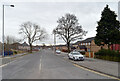
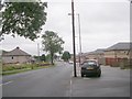
1
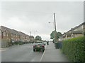
Heath Hall Avenue - Burnham Avenue
Image: © Betty Longbottom
Taken: 26 Aug 2009
0.03 miles
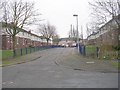
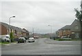
2
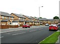
Burnham Avenue
Modern housing development.
Image: © Betty Longbottom
Taken: 26 May 2007
0.04 miles
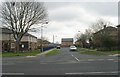
3
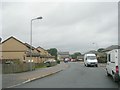
Bierley House Avenue - Heath Hall Avenue
Image: © Betty Longbottom
Taken: 26 Aug 2009
0.05 miles
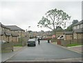
6
Neville Avenue - Bierley House Avenue
Image: © Betty Longbottom
Taken: 25 Feb 2011
0.07 miles
8
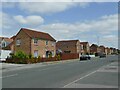
Modern houses on Burnham Avenue
This is a modern housing development replacing earlier social housing on the road, and stretching further back from it.
Image: © Stephen Craven
Taken: 4 Jun 2023
0.07 miles
10
Bierley House Avenue - Heath Hall Avenue
Image: © Betty Longbottom
Taken: 26 Aug 2009
0.07 miles