IMAGES TAKEN NEAR TO
Speights Place, BRADFORD, BD4 6HT
Introduction
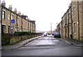
This page details the photographs taken nearby to Speights Place, BD4 6HT by members of the Geograph project.
The Geograph project started in 2005 with the aim of publishing, organising and preserving representative images for every square kilometre of Great Britain, Ireland and the Isle of Man.

There are currently over 7.5m images from over14,400 individuals and you can help contribute to the project by visiting https://www.geograph.org.uk
Image Map
Images are licensed for reuse under creativecommons.org/licenses/by-sa/2.0
Notes
- Clicking on the map will re-center to the selected point.
- The higher the marker number, the further away the image location is from the centre of the postcode.
Image Listing (102 Images Found)
Images are licensed for reuse under creativecommons.org/licenses/by-sa/2.0
Image
Details
Distance
2
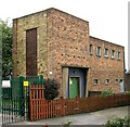
Electricity sub-station - Tong Street 758
Image: © Betty Longbottom
Taken: 26 May 2007
0.02 miles
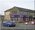
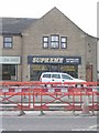
7
Sherburn House - Tong Street
This is a complex of small shops with accommodation above - it is becoming increasingly run down.
Image: © Betty Longbottom
Taken: 26 May 2007
0.04 miles
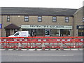
9

Toppers Unisex Hairdressing - Tong Street
Image: © Betty Longbottom
Taken: 3 Mar 2010
0.04 miles