IMAGES TAKEN NEAR TO
Knowles Street, BRADFORD, BD4 6HA
Introduction
This page details the photographs taken nearby to Knowles Street, BD4 6HA by members of the Geograph project.
The Geograph project started in 2005 with the aim of publishing, organising and preserving representative images for every square kilometre of Great Britain, Ireland and the Isle of Man.

There are currently over 7.5m images from over14,400 individuals and you can help contribute to the project by visiting https://www.geograph.org.uk
Image Map
Images are licensed for reuse under creativecommons.org/licenses/by-sa/2.0
Notes
- Clicking on the map will re-center to the selected point.
- The higher the marker number, the further away the image location is from the centre of the postcode.
Image Listing (86 Images Found)
Images are licensed for reuse under creativecommons.org/licenses/by-sa/2.0
Image
Details
Distance
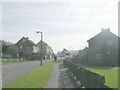
1
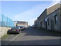
Knowles Street - looking towards Tong Street
Image: © Betty Longbottom
Taken: 1 Mar 2011
0.02 miles
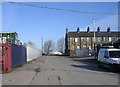
2
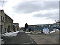
Knowles Street
A rather drab and untidy industrial street, made to look worse by the lingering snow and rubbish dumped at the bottom.
Image: © Stephen Armstrong
Taken: 1 Apr 2013
0.03 miles
4
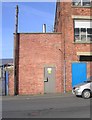
Electricity Substation No 66 - Prince Street
Image: © Betty Longbottom
Taken: 1 Mar 2011
0.04 miles
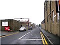
5

Prince Street - looking towards Tong Street
Image: © Betty Longbottom
Taken: 1 Mar 2011
0.04 miles
7
Law Street - looking towards Rook Lane
Image: © Betty Longbottom
Taken: 1 Mar 2011
0.06 miles
8

Step 2 Young People's Health Project - Tong Street
Image: © Betty Longbottom
Taken: 3 Mar 2010
0.07 miles