IMAGES TAKEN NEAR TO
Howden Close, BRADFORD, BD4 0QD
Introduction
This page details the photographs taken nearby to Howden Close, BD4 0QD by members of the Geograph project.
The Geograph project started in 2005 with the aim of publishing, organising and preserving representative images for every square kilometre of Great Britain, Ireland and the Isle of Man.

There are currently over 7.5m images from over14,400 individuals and you can help contribute to the project by visiting https://www.geograph.org.uk
Image Map
Images are licensed for reuse under creativecommons.org/licenses/by-sa/2.0
Notes
- Clicking on the map will re-center to the selected point.
- The higher the marker number, the further away the image location is from the centre of the postcode.
Image Listing (67 Images Found)
Images are licensed for reuse under creativecommons.org/licenses/by-sa/2.0
Image
Details
Distance
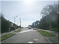
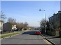
2
Holme Lane - viewed from Madison Avenue
Image: © Betty Longbottom
Taken: 14 Mar 2011
0.02 miles
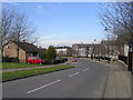
3
Holme Lane - viewed from Denbrook Avenue
Image: © Betty Longbottom
Taken: 14 Mar 2011
0.02 miles
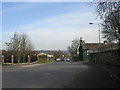
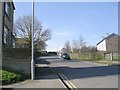
4

Junction of Denbrook Avenue and Holme Lane
The end of the avenue is closed to motor traffic.
Image: © Stephen Craven
Taken: 5 Sep 2020
0.03 miles
5
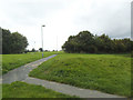
Southern end of Pit Hill Park, Tong
This is the entrance from Holme Lane. As the name suggests, this was formerly the site of Tong Colliery.
Image: © Stephen Craven
Taken: 5 Sep 2020
0.04 miles
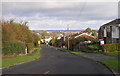
6
Holme Lane - viewed from Denbrook Avenue
Image: © Betty Longbottom
Taken: 14 Mar 2011
0.05 miles
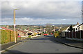
8

Denbrook Way, Tong
Looking downhill with a distant view towards Leeds.
Image: © Stephen Craven
Taken: 5 Sep 2020
0.06 miles