IMAGES TAKEN NEAR TO
Danecourt Road, BRADFORD, BD4 0DE
Introduction
This page details the photographs taken nearby to Danecourt Road, BD4 0DE by members of the Geograph project.
The Geograph project started in 2005 with the aim of publishing, organising and preserving representative images for every square kilometre of Great Britain, Ireland and the Isle of Man.

There are currently over 7.5m images from over14,400 individuals and you can help contribute to the project by visiting https://www.geograph.org.uk
Image Map
Images are licensed for reuse under creativecommons.org/licenses/by-sa/2.0
Notes
- Clicking on the map will re-center to the selected point.
- The higher the marker number, the further away the image location is from the centre of the postcode.
Image Listing (67 Images Found)
Images are licensed for reuse under creativecommons.org/licenses/by-sa/2.0
Image
Details
Distance
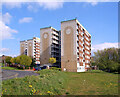
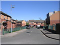
2
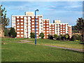
Flats on Dane Court Road, Holme Wood
Ogden House and Kelvin House on Holme Wood estate. These are the only blocks of flats in Holme Wood, the rest of the estate is low rise as shown in other photos.
Image: © David Spencer
Taken: 8 Aug 2005
0.02 miles
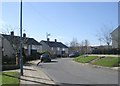
5
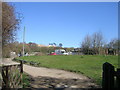
Entrance to Springfield Community Garden - Copgrove Road
Image: © Betty Longbottom
Taken: 22 Mar 2011
0.08 miles
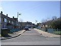
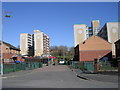
6
Ingleborough Close - Copgrove Road
Image: © Betty Longbottom
Taken: 22 Mar 2011
0.08 miles
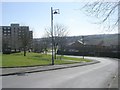
7
Stirling Crescent - viewed from Copgrove Road
Image: © Betty Longbottom
Taken: 22 Mar 2011
0.09 miles