IMAGES TAKEN NEAR TO
Sandford Road, BRADFORD, BD3 9NT
Introduction
This page details the photographs taken nearby to Sandford Road, BD3 9NT by members of the Geograph project.
The Geograph project started in 2005 with the aim of publishing, organising and preserving representative images for every square kilometre of Great Britain, Ireland and the Isle of Man.

There are currently over 7.5m images from over14,400 individuals and you can help contribute to the project by visiting https://www.geograph.org.uk
Image Map (Loading...)


Getting Data...Please wait
Leaflet Map data © OpenStreetMap
Images are licensed for reuse under creativecommons.org/licenses/by-sa/2.0
Notes
- Clicking on the map will re-center to the selected point.
- The higher the marker number, the further away the image location is from the centre of the postcode.
Image Listing (140 Images Found)
Images are licensed for reuse under creativecommons.org/licenses/by-sa/2.0
Image
Details
Distance
1
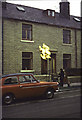
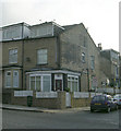
Fitzroy Road Bradford, Gas Conversion 1973
Image: © Alan Longbottom
Taken: Unknown
0.03 miles
3
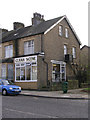
Clean Scene Launderette - Barkerend Road
Image: © Betty Longbottom
Taken: 8 Nov 2009
0.05 miles
5
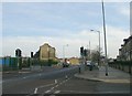
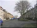
Barkerend Road - looking towards Thornbury
Image: © Betty Longbottom
Taken: 10 Jan 2009
0.06 miles

8
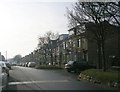
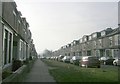
Wellands Terrace - Amberley Street
Image: © Betty Longbottom
Taken: 10 Jan 2009
0.06 miles
10
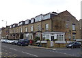
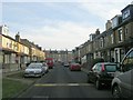
Houses on Barkerend Road, Bradford
Showing position of Postbox No. BD3 229.
See Image] for postbox.
Image: © JThomas
Taken: 14 Feb 2020
0.07 miles