IMAGES TAKEN NEAR TO
Barkerend Road, BRADFORD, BD3 9BE
Introduction
This page details the photographs taken nearby to Barkerend Road, BD3 9BE by members of the Geograph project.
The Geograph project started in 2005 with the aim of publishing, organising and preserving representative images for every square kilometre of Great Britain, Ireland and the Isle of Man.

There are currently over 7.5m images from over14,400 individuals and you can help contribute to the project by visiting https://www.geograph.org.uk
Image Map (Loading...)


Getting Data...Please wait
Leaflet Map data © OpenStreetMap
Images are licensed for reuse under creativecommons.org/licenses/by-sa/2.0
Notes
- Clicking on the map will re-center to the selected point.
- The higher the marker number, the further away the image location is from the centre of the postcode.
Image Listing (451 Images Found)
Images are licensed for reuse under creativecommons.org/licenses/by-sa/2.0
Image
Details
Distance
1
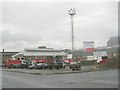
Harris Street Waste Management Department Depot - Harris Street
Image: © Betty Longbottom
Taken: 22 Nov 2010
0.03 miles
3
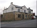
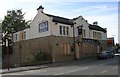
Sarah Interiors - Barkerend Road
This was formerly The Barkerend Public House.
Image: © Betty Longbottom
Taken: 8 Nov 2009
0.04 miles
4
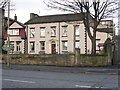
Hillside Manor Residential Home - Barkerend Road
Image: © Betty Longbottom
Taken: 8 Nov 2009
0.04 miles
5
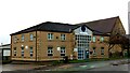
Appleton House, Barkerend Road, Bradford
A Training Centre run by Bradford Council.
Image: © Stephen Armstrong
Taken: 25 Dec 2022
0.04 miles
6
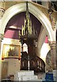
St Mary's Catholic Church - East Parade - Pulpit
This Church was closed on 11th Nov 2006 - plans are currently under consideration for converting it for use by the Emmaus Community in Bradford.
Image: © Betty Longbottom
Taken: 18 Apr 2013
0.04 miles
7
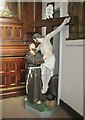
St Mary's Catholic Church - East Parade - Statue of St Francis
This Church was closed on 11th Nov 2006 - plans are currently under consideration for converting it for use by the Emmaus Community in Bradford.
Image: © Betty Longbottom
Taken: 18 Apr 2013
0.04 miles
8
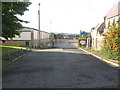
Heap Street, Barkerend Road
Leading to the now disused car park behind St Marys Catholic Church.
Image: © Stephen Armstrong
Taken: 12 Sep 2010
0.05 miles
9
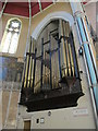
St Mary's Catholic Church - East Parade - Organ pipes
This Church was closed on 11th Nov 2006 - plans are currently under consideration for converting it for use by the Emmaus Community in Bradford.
Image: © Betty Longbottom
Taken: 18 Apr 2013
0.05 miles
10
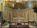
St Mary's Catholic Church - East Parade - Altar area
This Church was closed on 11th Nov 2006 - plans are currently under consideration for converting it for use by the Emmaus Community in Bradford.
Image: © Betty Longbottom
Taken: 18 Apr 2013
0.05 miles