IMAGES TAKEN NEAR TO
Derby Road, BRADFORD, BD3 8QA
Introduction
This page details the photographs taken nearby to Derby Road, BD3 8QA by members of the Geograph project.
The Geograph project started in 2005 with the aim of publishing, organising and preserving representative images for every square kilometre of Great Britain, Ireland and the Isle of Man.

There are currently over 7.5m images from over14,400 individuals and you can help contribute to the project by visiting https://www.geograph.org.uk
Image Map
Images are licensed for reuse under creativecommons.org/licenses/by-sa/2.0
Notes
- Clicking on the map will re-center to the selected point.
- The higher the marker number, the further away the image location is from the centre of the postcode.
Image Listing (184 Images Found)
Images are licensed for reuse under creativecommons.org/licenses/by-sa/2.0
Image
Details
Distance

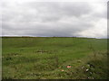
4
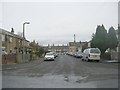
Petrie Road - off Wensleydale Road
Image: © Betty Longbottom
Taken: 14 Nov 2010
0.04 miles
5
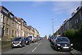
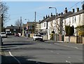
Lower Rushton Road - viewed from Dick Lane
Image: © Betty Longbottom
Taken: 16 Oct 2008
0.06 miles
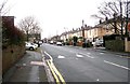
8
Nottingham Street, Thornbury
Seen from the junction with Dick Lane.
Image: © Rich Tea
Taken: 25 Apr 2006
0.07 miles