IMAGES TAKEN NEAR TO
Thornbury Drive, BRADFORD, BD3 8JD
Introduction
This page details the photographs taken nearby to Thornbury Drive, BD3 8JD by members of the Geograph project.
The Geograph project started in 2005 with the aim of publishing, organising and preserving representative images for every square kilometre of Great Britain, Ireland and the Isle of Man.

There are currently over 7.5m images from over14,400 individuals and you can help contribute to the project by visiting https://www.geograph.org.uk
Image Map
Images are licensed for reuse under creativecommons.org/licenses/by-sa/2.0
Notes
- Clicking on the map will re-center to the selected point.
- The higher the marker number, the further away the image location is from the centre of the postcode.
Image Listing (212 Images Found)
Images are licensed for reuse under creativecommons.org/licenses/by-sa/2.0
Image
Details
Distance

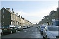
2

Rushton Road - viewed from Leeds Old Road
Image: © Betty Longbottom
Taken: 23 Oct 2008
0.04 miles
3

Jamia Masjid - viewed from Thornbury Drive
Image: © Betty Longbottom
Taken: 30 Apr 2018
0.05 miles
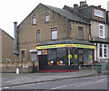
7
Karachi Fabrics - Thornbury Avenue
Image: © Betty Longbottom
Taken: 22 Oct 2009
0.06 miles
9
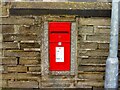
Queen Elizabeth II Postbox, Leeds Old Road, Bradford
Postbox BD3 233 at the corner of Upper Rushton Road.
Image: © Stephen Armstrong
Taken: 24 Jan 2023
0.06 miles
10
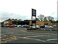
Aldi, Leeds Old Road, Bradford
Opened in February 2020 at the corner of Rushton Road, on the site of a former school.
Image: © Stephen Armstrong
Taken: 25 Apr 2022
0.07 miles